| |
|
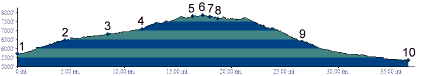
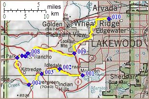
01.(5720ft,mile00) START-END SOUTH: Morrison, jct C470 -
Bear Creek Canyon
02.(6470ft,mile05) Idledale and (dirt) turnoff to
Grapevine/Sawmill Gulch is on right
03.(6820ft,mile08) Kitridge and turnoff to Dix Saddle (aka
Parmalee Gulch) is on left
04.(7080ft,mile12) Evergreen, stay right at lake
05.(7790ft,mile17) Bergen Park, lower turnoff on Co74
06.(7860ft,mile18) TOP: point of highest altitude on Co74
bypass. I use 7840ft for summit elevation. This is the
intersection of Bergen Pkwy with Evergreen Pkwy.
07.(7780ft,mile18) turnoff down Kerr Gulch is on right
08.(7670ft,mile19) El Rancho
09.(6400ft,mile27) START-END EAST ALTERNATE: turn from
Mount Vernon Canyon left onto US40 which becomes Colfax
Ave.
10.(5360ft,mile37) START-END EAST: Clear Creek bike path
at Kipling Ave.