| |
|
|
|
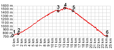
1.(00.0km,726m) START-END NORTH: la Fonderie in Allemond
2.(01.2km,800m) profile turns right after crossing dam over Lac du Verney
3.(11.6km,1452m) Villard Reculas
4.(13.1km,1538m) TOP: point of highest elevation
5.(15.2km,1429m) road joins Alp d'Huez road; profile turns right
6.(24.2km,715m) START-END SOUTH: jct N91 - road to Alp d'Huez, on the north west end of Bourg d'Oisans
|
|