| |
| |
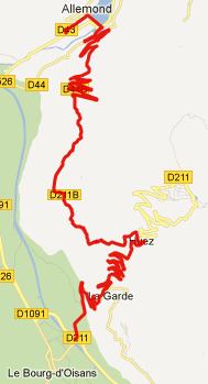
D211B Villard Reculas s(u)
This is one of the
balcony-like roads, that line the mountain sides
above Bourg d'Oisans. One view, that (I think)
would entice any avid cyclist to ride this, is
from a descend of Col
d'Ornon. From that vantage point it seems
hard to believe, that a road could reach this
group of houses on top of folded rock layers, that
seem like a 1000m high layered croissant, cut
cleanly with a knife.
My 1:200 000 Michelin map of the Rhone alps shows the name Col du Poutran at this location. However I checked in with the tourist department in Villard Reculas, and sure enough - Col du Poutran can be accessed by bike, but an MTB would be much better. It is located on a trail of sorts in the ski area, and several lifts carry the same name. They have a detailed map to prove it.
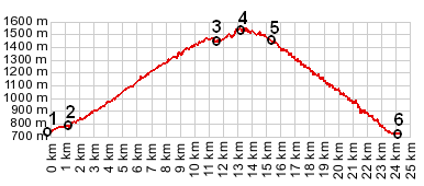
From North. North of the village Allemond
the main road climbs up to a dam, and then
traverses it, giving a nice overview of the town.
The road to Villard Reculas branches off this main
road after it has crossed the dam. A wide road
affords better and better views of the Belledonne
chain of mountains, as it climbs to the south. But
the even more dramatic views are still to come.
After providing a elaborate work out, the road
switches onto the north side of the ridge, and now
for the first time gives an impression of the full
depth of the Gorge de la Romanche. The point of
highest altitude comes after going through the
village of Villard Reculas. Here the view shed
changes to take in the north of the valley. The
road along the summit is much narrower and many
benches line the hillside, providing a wide
selection of a lunch pique-nique sites. Up here
you have little idea that you are actually on top
of a very precipitous cliff. But looking across
the hillside, and seeing the corresponding rock
layers, sliced down to the valley, as if cut with
a knife, gives a good idea of what this side looks
like From South. The road continues to
traverse the hillside, giving more of what a
balcony road has to offer - balcony views, and
then enters the lower older part of Huez. The drop
between the high point and the jct with the Alp
d'Huez climb measures a little more than a 100m on
the map, making this a summit as opposed to a
shoulder summit.
A Dayride
with this point as intermediate summit is on the
page: Col de Solud The last summit ride with
different start and end points on this Extended Tour
is on the page: Col de Morte
|
 Approaches
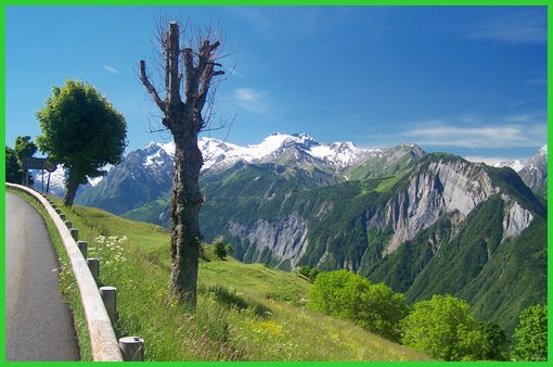
|
|
advertisement |
|
|
advertisement |