| |
|
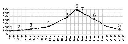
1.(00.0km,80m) START-END 1:
la Trinite
2.(02.3km,100m)Cantaron
3.(05.3km,130m)jct D2204 - D15, profile goes left on D15
4.(09.7km,220m)profile turns right from D15 onto D616 in
Contes
5.(14.0km,470m)profile takes steep concrete path on left
6.(16.5km,670m)TOP: Berre les Alpes
7.(18.0km,590m)D215 - D615 Berre les Alpes(shp)
8.(21.0km,410m)Col De Nice(shp): profile turns right down
D2204
9.(27.3km,130m)START-END 2: jct D2204 - D15, same as point
3