Chemin de Greo: Berre les
Alpes
When looking at a 1:200 000 map
of the Berre les Alps area, it may look the final
km to Berre les Alps has to be an out and back
ride, if restricting yourself to pavement.
Actually, with help of the completely paved Chemin
de Greo, the town square becomes the highest point
on a completely paved loop.
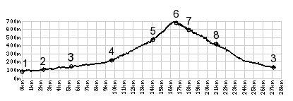 |
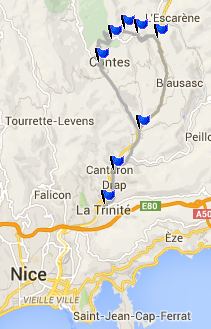
1.(00.0km,80m)
START-END 1: la Trinite
2.(02.3km,100m)Cantaron
3.(05.3km,130m)jct D2204 - D15, profile
goes left on D15
4.(09.7km,220m)profile turns right from
D15 onto D616 in Contes
5.(14.0km,470m)profile takes steep
concrete path on left
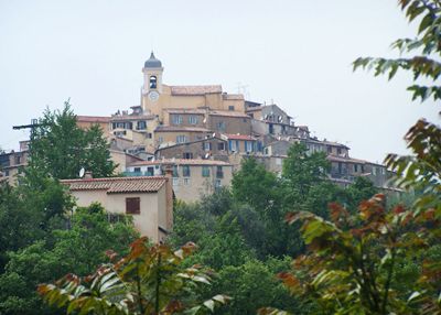
6.(16.5km,670m)TOP: Berre les Alpes
7.(18.0km,590m)D215 - D615 Berre les
Alpes(shp)
8.(21.0km,410m)Col De Nice(shp): profile
turns right down D2204
9.(27.3km,130m)START-END 2: jct D2204 -
D15, same as point 3 |
 Approaches Approaches
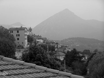
From West. When starting
this climb from Contes (point 4), another old hill
town can be seen clinging to the ridge line ahead.
In the upper part of the climb, after the
switchbacks in Contes are far below and the Contes
churchtower looks like a model display, a total of
3 signed turnoffs on the left pass the tired
cyclist. The last one of them, clearly signed as
"Chemin de la Greo" and also "Creme des Marrons"
(is this a business ?), actually goes al the way
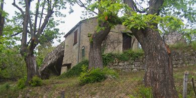
through to the top. Along the way the narrow road
passes between many glacial erratic rocks, so
large that one house actually uses one such rock
as a wall. The road emerges onto the main spur
from Berre les Alps at its highest point, across
from the cemetery. The "creme de Marrons"
destination is signed on this side too, the
"Chemin de Greo" designation is missing.
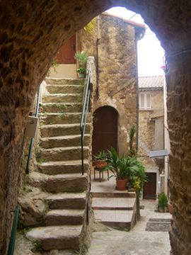
From East. A short
roll down leads to the main square of the town.
Exploring around in the few medieval alleys in the
town core feels much more peaceful than in the
more popular hilltowns, like Eze for example. But
the best view of Berre les Alps is still from
below on this side, shortly before the road merges
with D615. The profile coninues to the Col de Nice and goes
downhill back to Nice. A better bike route, and
only a very short detour substitutes the road
through Bausasc for busy D2202. But riding around
the lower part takes much more climbing.
|
---------------------------------------------------- |
---------------------------------------
---------------------------------------
in and around Berre les Alpes
--------------------------------------: |
Dayride with this point as highest summit
COMPLETELY PAVED:
Chemin de Greo: Berre les Alps s(u) , Col de
Chateauneuf , D719
Aspremontt(sh) : Nice > Route de
Bellets > D719 Aspremont s(u) <> out and
back to the highest part of Aspremont >
Tourette-Levens > M19 north > Col de
Chateauneuf > D815 north > up Chemin de la
Greo > Chemin de la Greo: Berre les Alpes s(u)
> Col de Nice(shp) > Blausasc > Cantaron
> Drap > Nice with Detours : 53.1m with
4972ft of climbing in 5:16hrs VDO MC1.0
m4:14.5.10).
Notes: This route crosses the three major
foothill ridges, immediately north of Nice
between the rivers Var and Paillon -
mileage includes weekend food shopping on the
way back, with a finish crawling through Nice
city streets.
The first day with different start and end points
on this tour is on page: Col de Palmarella/
Col de la Croix
|