| |
|
|
|
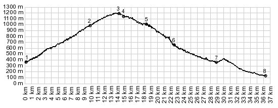
1.(140m,km00) START-END
SOUTH 1: jct D2204-D2566 l'Escarene
2.(370m,km10) profile turns left onto D54, just before
reaching Col de Braus
3.(1250m,km15) TOP: Col de l'Orme s(u)
4.(1200m,km15) Col de l'Able
5.(1130m,km19) route turns left onto D21, coming down
from Col de Turini; Col de l'Orme is located about
1/4th of the distance back to point 4.
6.(1010m,km23) Luceram
7.(630m,km29) START-END SOUTH 2: same as point 2
8.(370m,km37) START-END SOUTH ALT: jct D2204-D15 la
Pointe de Blausasc
|
|