| |
| |
Col de l'Orme s(u)
Hard to decide weather this road has more
horizontal curves or vertical curves, that is
actual turns in the road, or surface waves. One
thing is for sure, it does wind around a lot,
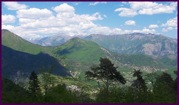
mostly on this side. Through the trees great views
of Sospel, Col St Jean and the snowcapped peaks
behind it appear. The highest point is still in
the trees, but has a good far view of the road up
l'Authion. From West. (described
downwards). Col de l'Orme is signed, and the sign
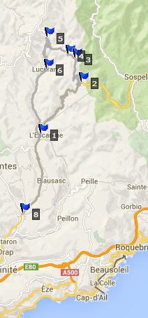
appears at a dip in the road. A trail crosses
here, connecting Sospel with a point further down
on the road described here, and eventually
Luceram. After "crossing" the actual point Col de l'Orme,
the road ends at a T which connects Col de Turini with
Luceram. The profile turns left and the best part
of this ride is still ahead. It is the final
flurry of extended switchbacks that show off
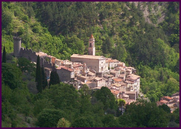
Luceram from new angles. Unlike almost all other
hilltowns so close to Nice, this one is not
surrounded by modern bungalows. In order to get
that illusion of picturesqueness, you do not have
to choose your frame of view. The two church
towers of this town town shift in position with
every switchback. The profile continues downhill
all the way to the outskirts of Nice to show a
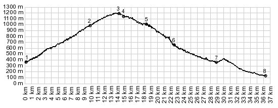
maximum elevation gain. Dayride with this point as highest summit: PARTIALLY PAVED / UNPAVED: Col de l'Orme s(u) , Chemin
Strateguique des Banquettes , Col du Savel , Col de Pacrace :
Nice - St Margaruite > beach bike path
west > Nice Port > Col de Quatre
Chemins(shp) > Col d'Eze(shp) > La Turbie
> Col Pacrace > Peille > Chemin
Strategique des Banquettes west > Col des
Banquettes(shp) > Col Segra (shp) > Col du
Farguet(shp) > Chemin Stratgique des Banquettes
s(u) > Col du Braus(shp) > Col de l'Orme
s(u) > Luceram > up Chemin des Mounts >
Col du Savel > Coroaze > Drap > Nice Port
> beach bike path and city streets back to
starting point: (80.0 miles with 7759ft of
climbing in 7:47hrs Garmin Etrex30 m4:14.5.15). The first day with different start and end points
on this tour is on page: Col de Palmarella/
Col de la Croix
between Col de Braus and Col de
l'Orme
|
|
|
advertisement |
|
|
advertisement |