| |
|
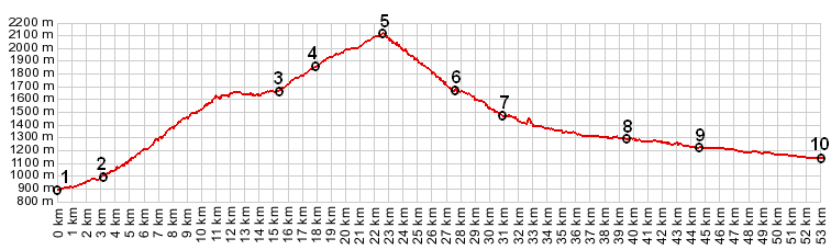
01.(00.0km,890m) START-END NORTH ALT: jct N94 - road to Guillestre
02.(03.3km,1000m) START-END NORTH: Guillestre
03.(13.5km,1630m) Marcelin
04.(18.0km,1864m) Station de Vars
05.(22.5km,2109m) TOP: Col de Vars
06.(27.4km,1660m) Melecen
07.(30.9km,1468m) START-END SOUTH: St Paul sue Ubaye and turnoff to upper Ubaye valley on left
08.(39.5km,1282m) la Condamine and turoff to tunnel Parpaillon on left
09.(44.7km,1228m) Jausiers
10.(53.0km,1135m) START-END SOUTH ALT: Barcelonnette, bridge over Ubaye south west of town
|