| |
|
|
|
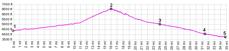
1.(1340m~4396ft,km00.0~00.0mi) START-END
EAST: jct Mt73-Nez Perce Road
2.(2008m~6587ft,km25.9~16.1mi) TOP: Nez Perce Pass
3.(1540m,~5052ft,38.7km~24.0mi) dirt road to Hell's
Half Acre Creek drainage diverts on left
4.(1258m~4127ft,50.5km~31.4mi) Sellway River joins
Deep Creek from left
5.(1160m~3806ft,55.9km~34.7mi) START-END WEST: jct
FR6223 - Nez Perce Trail Rd (Magruder Coridor Rd)
|
|