| |
| |
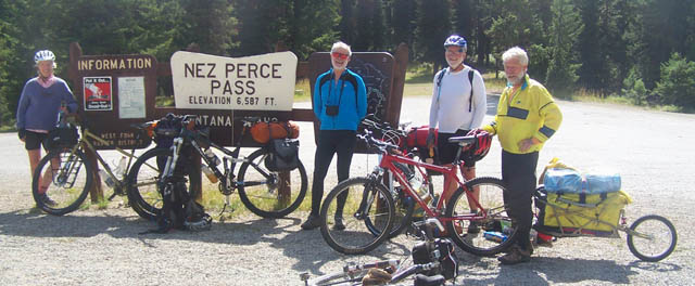
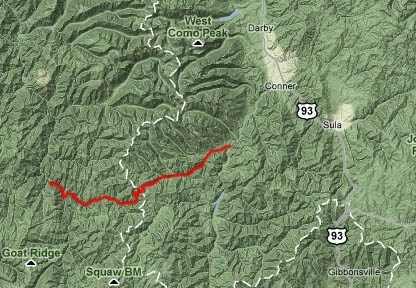
Nez Perce Pass
Nez Perce Pass is perfect for
mountain bike tourers, who don't object to a
smooth road. The road over the top is paved with a
sturdy pebble matrix. But sections of the lower
approaches on each side are dirt road. This makes
for a quiet, traffic free ride that still moves
along lickety split. The special feeling imparted
by this pass is one of climbing in very remote
hills, that give the impression that this green,
rolling landscape goes on forever in all
directions, undisturbed by any major traffic
thoroughfare - just these small, functional forest
roads, that are masked as impractical dirt roads
to the uninitiated.
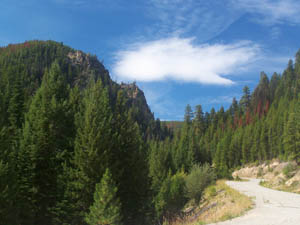
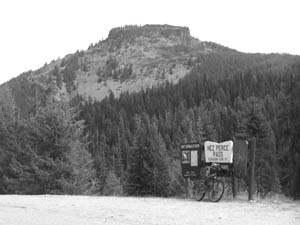
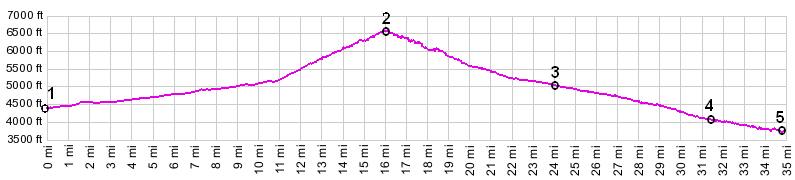
From East. The route to the pass is not only starts very shallow, it also continues very shallow for a long distance, such a long distance that considerable elevation gains is accumulated despite the small slope. The profile starts, where Nez Perce Road turns off Mt473. The description starts a bit lower, where MT473 turns off US93 south of Sula. From here a pleasant paved road leads past occasional large houses and well labeled forest road turnoffs, that act as invitation to explore the Bitterroot Range further. Substantially up that road, past the ranger station, the turnoff onto Nez Perce Road is labeled. After several miles the road becomes dirt, but continues almost straighter than before, like a well grown branch that knows exactly what it is striving for. The surface has some washboard characteristics, but is really not bad at all, no sand or gravel. Shortly before a campground, rough pebble pavement starts up again and the climb is now more than noticeable. The road switches back in front of Castle Mountain, the only real landmark along the entire route. Castle Mountain is a small flat topped mesa with cliffs on all sides, that must have acted as superb landmark for the Indians when this was their trail. The road switches back again and traverses around a few wooded hills to a plainly visible gap ahead. This time the visible gap turns out to be the destination pass. Far views are limited. A few high ridges reaching above treeline, located on the eastern escarpment of the Bitterroot Range, can be made out through the trees just before reaching the pass. On the top is an elaborate sign with a carved map and trailhead parking, along with another limited view down the west side. The trails leaving along the ridge are not legal for bicycles since both sides are designated wilderness areas. This pass is not on the continental divide, even
though it is on the Idaho - Montana border and on
the crest of the Bitterroot Range. One of the many
quirks of the continental divide is that it leaves
the Bitterroot Range for an abrupt easterly
departure at Gibbons Pass (to the south) in order
to follow the crest of the Anaconda Range,
From West. (also described upwards) A low
point on this side is located at the Mac Gruder
ranger station. A dirt road follows Deep Creek,
traversing splendid deep forest isolation. It
passes at least two campsites, which have very
high bars to keep food from bears. These bears
apparently have fantastic climbing and high
jumping abilities, judging from the height of
these food storage structures. I didn't see any
picnic tables. Soon the pavement starts, and stays
all the way to the summit. Along the way are a few
tall gate-like rocks through which the road
passes, but no real landmarks that easily stick to
memory.
Dayride An out and back ride from a campsite a mile up FR49 Priquett Creek (located along Mt473 several miles below the Nez Pass Rd turnoff ) <> up M473 <> Nez Perce Road <> Nez Perce Pass <> turnaround point at the CCC camp, a few miles short of Mac Gruder ranger station measured 73 miles with 4600ft of climbing in 6:hours. (VDO MC1.0 m3:10.9.7).History Stevens Expedition (<Marias pass): In
the 1850s this pass was located in Washington
territory. Of course the pass did not move, but
the definition of Washington territory changed. It
stretched from the Montana Rockies to the Pacific
- and Major Stevens wanted to be its first
governor. He got the job and also managed to
assemble a large exploratory force in 1853,
consisting of 240 men, against political
opposition. If Washington Territory was going
become important, it needed a railroad - so he
thought - and he would show that a northern route
is better than Gunnison's proposed route over Cochetopa Pass in
Colorado. But plans to lay rails were cut off by
Civil War tensions. In any case, the list of
passes explored during the Stevens Expediton years
is a long one. It also included five new
Bitterroot Range crossings, among them Nez Perce
Pass. back to Montana's passes and summits by bicycle |
 Approaches