|
-
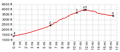
1.(1450ft,mile00.0)START-END
EAST: jct US26 - Lolo Pass Rd
2.(2520ft,mile06.1)jct with FR39 Kiwani's Camp Rd
on left
3.(3760ft,mile10.4)profile takes left turnoff to
Government Campurns left away from US26
4.(3990ft,mile11.6)route rejoins US26
5.(4030ft,mile11.8)TOP: jct with Timberline Hwy to
Timberline Lodge
6.(3410ft,mile16.3)START-END WEST: low point on
US26 before climbing to Wapinitia Pass
View Or_or35_government_camp_sh in a larger map |
-