|
-
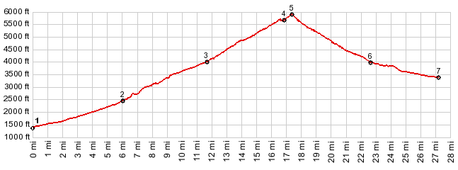
1.(1450ft,mile00.0)START-END
EAST: jct US26 - Lolo Pass Rd
2.(2520ft,mile06.1)jct with FR39 Kiwani's Camp Rd
on left
3.(4040ft,mile11.8)profile turns left away from
US26
4.(5660ft,mile16.7)end of Timberline West Rd.
Profie makes loop to lodge
5.(5900ft,mile17.4)TOP: Timberline Lodge
6.(4020ft,mile22.6)profile turns left, back onto
US26
7.(3410ft,mile27.2)START-END WEST: low point on
US26 before climbing to Wapinitia Pass
View Or_timberline_lodge_u.gpx in a larger map |
-