| |
Timberline Lodge: Mount
Hood
The ride to this high ski
lodge can be made into a two-way summit (two
separate approaches) with the help of a low
traffic, yet completely paved ski area service
road. Once on top you are are about equally
distant in elevation from Portland as from the
top of the Mountain. You can't see Portland,
but the the view of Mount Hood is a big
attraction.
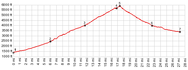
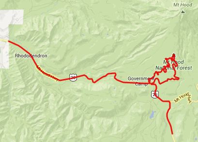
A From West. It's hard to
decide where on US26 to start this profile, so
I'll start it where my ride turned onto US26,
the junction with East Lolo Pass Road, also the
way to Lost Creek campground, and a whole world
of trailheads into the Mount Hood region. I found riding on US26 to be very
unpleasant. The reason is the noise. Any highway
where most of the space is occupied by moving
cars is going to be noisy. But this one seems to
be much worse. Maybe it's the lack of curvature,
so that every driver feels obligated to press on
the gas pedal till the speedometer reads the
speedlimit. Maybe it's the weight of all the
contraptions that these climbing vehicles carry
behind them, boats living spaces with grey and
black water tanks that need to be emptied ...
Maybe it's the proximity of Portland that makes
traffic heavy. Actually, it's probably all of
these. That being said, this is a perfectly save
and civilized ride on a spacious shoulder. And
Oregonians on the west side of the Cascades
would never think of putting a rumble strip down
the middle of it, like they do in barbarian
states like Nevada, Montana, Utah and Colorado.
And maybe I just hit a very popular traveling
time also, a late Sunday when Portlanders take
the first step of returning to work, race back
home to get some sleep. The second time I rode
down this road on a Wednesday evening wasn't
nearly as bad. 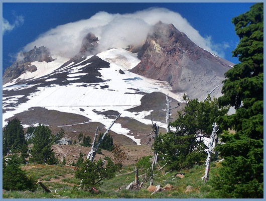 telephote view from a few steps above Timberline Lodge One way I found to get away from
the traffic for a while was on a side road
labeled "Kiwani Camp". After several miles it
dead ends, but a section of abandoned highway,
now closed to cars leads back to the main road
through a canopy of green. Coming the other way
it's possible to find this trail directly behind
the sign reading "Truck Runoff Ramp 1 mile". Now fortified by half an hour of
peace and silence I braved the remaining miles
to the turnoff to Government Camp Village on
US26. It's not necessary to ride the short
detour through this skiing village, neither is
it very scenic. But the next turnoff up West Leg
Road is not exactly easy to find, and the lady
in the information office (clearly labeled as
such on the east end of town) was happy to
repeatedly give me detailed descriptions on how
to find it. Actually it does not sound
difficult. Basically it's the first left after
one is back on US26, and then the next immediate
left (unsigned) after that. This narrow isolated
road, named West Leg Road, traverses across ski
runs up the lower slopes of Mount Hood. The peak
is visible once in a while, looking up the ski
runs. This section is the best part of the
workout and it ends where the ski run road
terminates on Or173. From here Timberline Lodge
is just a minute away, Here OR173 begins its top
section, a one way loop with the lodge at the
top. So this route is a two way summit that does
not double back on itself, but it does cross
over itself. Timberline Lodge is an old
historic ski lodge with interesting art work and
unique architecture, and also some great views
at last of Mount Hood, from north of the lodge.
The size of the parking lot up here is measured
in football fields.
Dayride PARTIALLY PAVED / UNPAVED ( < FR17
Cougar Mountain s(u) | Bennett Pass
> ) - |
 pproaches
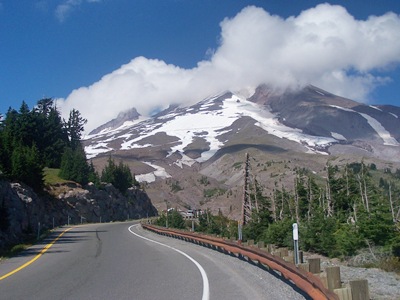 From East. The
rider speeds past the "breadth recovery zone",
where West Leg Road ended, heading down the
forested slopes along Or173. The view below is
of green hills in a haze with a singular
lonesome lake nestling in them. There is a good
shoulder, but heavy and unpredictable traffic,
including a noxious smelling diesel bus from the
ski lodge. Or173 rejoins US26 just a few hundred
yards from where West Leg Road diverted from it.
If having come up that way for a day long ride,
the return will most likely also go back down
it. But in order to show the climb from the
other side the profile goes south on US26 to a
low point, before it climbs again up to
Wapinitia Pass.
From East. The
rider speeds past the "breadth recovery zone",
where West Leg Road ended, heading down the
forested slopes along Or173. The view below is
of green hills in a haze with a singular
lonesome lake nestling in them. There is a good
shoulder, but heavy and unpredictable traffic,
including a noxious smelling diesel bus from the
ski lodge. Or173 rejoins US26 just a few hundred
yards from where West Leg Road diverted from it.
If having come up that way for a day long ride,
the return will most likely also go back down
it. But in order to show the climb from the
other side the profile goes south on US26 to a
low point, before it climbs again up to
Wapinitia Pass.|
|
advertisement |
|
|
advertisement |