| |
|
|
|
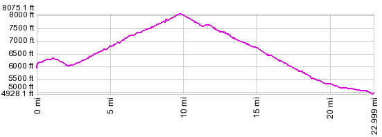
the two low points at the beginning are not as low as they appear because of bridges.
local units:
01.(mile00,5580ft) START-END WEST: Chief Joseph Highway crossing Basin Creek
02.(mile01,6240ft) intermediate high point
03.(mile02,6070ft) START-END WEST ALTERNATE: Chief Joseph Highway crossing Indian Creek
04.(mile10,8048ft) Dead Indian Pass
05.(mile23,4990ft) START-END EAST: jct Mo120 - Chief Joseph Highway
metric units:
01.(km00.0,1880m) START-END WEST: Chief Joseph Highway crossing Basin Creek
02.(km01.6,1900m) intermediate high point
03.(km03.8,1850m) START-END WEST
ALTERNATE: Chief Joseph Highway crossing Indian Creek
04.(km15.7,2453m) Dead Indian Pass
05.(km37.0,1520m) START-END EAST: jct Mo120 - Chief Joseph Highway
04.(km15.7,2453m) Dead Indian Pass
05.(km37.0,1520m) START-END EAST: jct Mo120 - Chief Joseph Highway
|