| |
| |
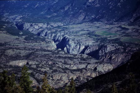
Dead Indian Pass 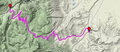 Dead
Indian Pass runs in an east westerly
direction, south of Beartooth Pass.
The proximity makes the difference between
these two passes even more amazing. While
Beartooth Pass crosses the "hard rock"
Beartooth Plateau, Dead Indian Pass crosses
the colorful, volcanic Absaroka mountains,
containing spires and interesting erosional
features. You rarely see the name "Dead Indian
Pass" anymore. Instead the more refined name
"Chief Joseph Highway" is used on road signs.
Regardless, both names commemorate not the
same Indian, but the same set of events, the
time when Chief Joseph and his Nez Perce
Indians were hunted halfways across the
continent because they could not live in the
reservation, deemed suitable by the
government. A detailed set of signs on the
summit inform about the battles fought and a
dead Indian left behind by the Nez Perce. Dead
Indian Pass runs in an east westerly
direction, south of Beartooth Pass.
The proximity makes the difference between
these two passes even more amazing. While
Beartooth Pass crosses the "hard rock"
Beartooth Plateau, Dead Indian Pass crosses
the colorful, volcanic Absaroka mountains,
containing spires and interesting erosional
features. You rarely see the name "Dead Indian
Pass" anymore. Instead the more refined name
"Chief Joseph Highway" is used on road signs.
Regardless, both names commemorate not the
same Indian, but the same set of events, the
time when Chief Joseph and his Nez Perce
Indians were hunted halfways across the
continent because they could not live in the
reservation, deemed suitable by the
government. A detailed set of signs on the
summit inform about the battles fought and a
dead Indian left behind by the Nez Perce.
Approaches From West. Chief Joseph
highway begins where either Colter Pass or
Beartooth Pass ends. Following the valley of
Clark's Fork of the Yellowstone south, Pilot
Peak (11708ft) is the scenic background to a
pastoral foreground for many miles. Pilot Peak
is true to its name. It is the outstanding
visual feature of all three pass approaches that
converge here. This side of the approach
contains ample rolling hills before the pass
proper even begins to start. It does so only
after crossing Clark's Fork of the Yellowstone
and climbing high above the deep canyon.
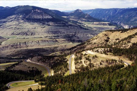
From East. The pass starts
to climb steeply right in the beginning. Far
flung switchbacks lead through colorful
sedimentary rocks to ever vaster views of the
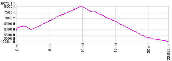
bleak Bighorn Basin below. 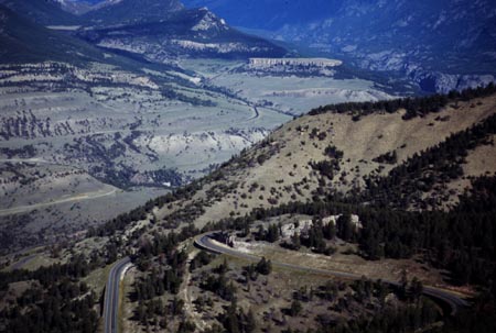 Tours Dayrides. A ride over Chief Joseph Highway from its junction with the Beartooth Pass road to its junction with Wy120, and back by the same route, measured 68 miles (no altitude data available). Two or Three Day road Tour.
The pass can be cycled in a circle
combined with the bigger Beartooth Pass,
completing the circle over Wy120 between Cody
and Red Lodge. In order to sleep somewhere
halfways civilized on a three day tour it is
necessary to add on an out and back section to
Cody. The other overnight stop is Red Lodge. An
additional out and back section to Cooke City or
West Yellowstone over Colter Pass is
also worthwhile. A two day version of this ride,
starting in Silver Gate ( located between Cooke
City and West Yellowstone ) and skipping the
detour to Cody, measured 112 miles over Colter
Pass, Dead Indian Pass and Wy120, 70 miles
between the same endpoints over Beartooth Pass
and Colter Pass again (no measured altitude data
available). It is described further on this page,
under the heading "my first Rocky Mountain
Pass".
|
|
|
advertisement |
|
|
advertisement |