| |
| |
Beartooth Pass In the western Wyoming mountain
ranges, at a safe distance from Yellowstone
National Park, it is nearly impossible to find a
road that is not worth bicycling. The highest
paved pass of this corner of the west, Beartooth
Pass, has another advantage. It is not plagued
by the traffic of a large adjacent metropolitan
area. Other potential crowds, the summer
vacation tourists, head straight for
Yellowstone. This leaves Beartooth Pass to be
enjoyed by cyclists who appreciate a good
climbing work out and unparalelled scenery. The
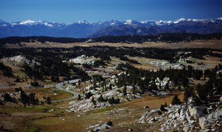
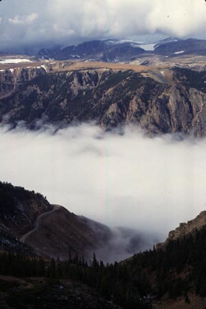
pass across the high rolling Beartooth Plateau
above treeline is surrounded by the Absaroka,
Beartooth and other ranges. Good weather is a
prerequisite for this ride. This pass is a
personal favorite and a description of a ride in
the "touring stories section" is on this page,
under the heading "my first Rocky Mountain
Bicycle Pass"
Approaches From East. The long distance tourist
approaching from Billings will notice the shallow
slope to Red Lodge. That's where the Beartooth
Highway and the pass road begins. After an
extended forest climb, passing many camping
opportunites (public land as well as National
Forest campgrounds), the road turns into a series
of ramps climbing the plateau. But this plateau is
anything but flat. The road has two summits, and
spectacular scenery separting them.
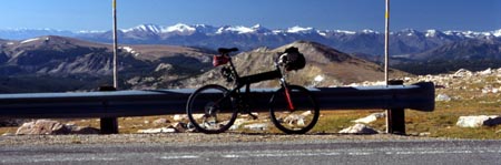
From West. The western approach begins at
the junction of three paved passes, Beartooth
Pass, Dead
Indian Pass and Colter Pass. The
character of this side is quite different, drier,
more sage and fewer pines, more varied colors and
less green. Pilot Peak, keeping watch above Colter
Pass is sure to get attention because of its shape
from this vantage point.
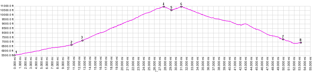
Dayrides. An out and back roadride from Red Lodge to the eastern summit measured 53 miles. The measured elevation gain of 6710ft overshoots the real value, either because of a week battery or a passing weather front. Two or Three Day road Tour. The pass
can be cycled in a circle combined with Chief
Joseph Highway over Dead Indian Pass, completing
the circle over Wy120 between Cody and Red Lodge.
In order to sleep somewhere halfways civilized on
a three day tour it is necessary to add on an out
and back section to Cody. The other overnight stop
is Red Lodge. An additional out and back section
to Cooke City or West Yellowstone over Colter Pass
is also worthwhile. A two day version of this
ride, starting in Silver Gate ( located between
Cooke City and West Yellowstone ) and skipping the
detour to Cody, measured 112 miles over Colter
Pass, Dead Indian Pass and Wy120, between Silver
Gate and Red Lodge, 70 miles between the same
endpoints over Beartooth Pass and Colter Pass
again (no measured altitude data available).
It is described further in the touring stories
section, linked in the first paragraph on this
page. Extended Tour. This pass is also in a
prime location for an extended tour, right on the
way to Yellowstone and the Tetons. Therefor it is
not surprising that I have met long distance
tourists every time that I have cycled this pass.
It was also a highpoint on my first long distance
bicycle tour from New York to California.
|
 Tours
Tours|
|
advertisement |
|
|
advertisement |