| |
|
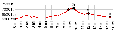
1.START-END WEST:Green River bridge,
east of town Green River
2.profile turns left along top of ridge
3.TOP: 7140ft
4.jct with out and back road to Wilkins Peak(ow)
5.profile turns left onto paved Wy191
6.START-END EAST:low point immediately before jct with
I80
|