| |
| |
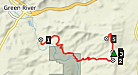
Wilkins Peak Rd s(u) The most obvious and easiest
accessible, great gravel ride in the Green RIver
area is a ride over the Wild Horse
Loop. During the ride high up on the
plateau, you might have noticed an microwave
tower across the valley, on the other side of
that transcontinental thoroughfare below,
comprised of I80 and the Union Pacific's main
line. It is Wilkins Peak and this road leads
there. In addition to the characteristic badland
cliffs of this area, it also includes a
substantial stretch of up and down Green River
shore cycling.
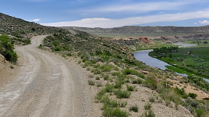
Scotts Bottom road on the other side
is named for a trapper's favorite Beaver Trapping
area along the river. Today the extremely rolling
gravel road is the scenic route along the Green
River. Several unsigned junctions allow exploring
the area next to the river. Other rough and steep
tracks lead higher away from the river. The
profile follows the most used option and
eventually winds around the south side of Wilkins
Peak, over a moderate ridge. After a junction with
another approach that stays on the east side of
the ridge, the road reaches a high point while
paralleling the ridge on the east side. In the
vicinity are many great views of the Uintahs and
the cliffs along the Green.
Sidetrip to Wilkins Peak
This out and back road is equally
well surfaced and bike friendly. There is a gate
not too far up. You can easily walk around it. The
views get better and newer as the road winds up to
the transmission towers. Other steeper ATV tracks
meet this road as it approaches the summit. There
are no gates on these other approaches.
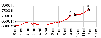
 Dayride
with this point as highest summit Dayride
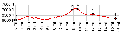
with this point as highest summitPARTIALLY PAVED / UNPAVED ( < CR173 Piedmont Rd s(u) | Old US30 s(u) > ) Wilkins Peak s(u) , additional out and back : a couple of miles up Wild Horse Canyon Rd > Wild Horse Canyon Rd south > Green River > Wy530 south > Upland Way east > Scott's Bottom Rd south <> out and back 2.2miles(ow) up unmarked double track direction WIlkins Peak >> road around south end of Wilkins Peak <> out and back to top of Wilkins Peak > Little Firehole Rd east > US191 north > I80 east > Green River > back to starting point on Wild Horse Canyon Rd: 44.3miles with 4130ft of cllimbing in 5:30hrs (garmin etrex32 m5:23.6.19) same summit point: a couple of miles up Wild Horse Canyon Rd > I80 west > US191 south > Little Firehole Rd west <> out and back to Wilkins Peak with several miles of out and back along the route >> Scott's Bottom Rd north > various streets south west > Green River > back to starting point on Wild Horse Canyon Rd: 46.3miles with 4760ft of climbing in 6:52hrs (garmin etrex32 m5.23.6.20). Notes: this ride was an unsuccessful attempt to recover lost keys along the route on the previous ride. It includes many miles of extra out and back and a long of time (and maybe abount 2 miles of walking) on the photo stops along the route. 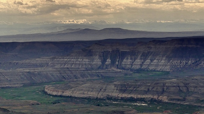 |
|
|
advertisement |
|
|
advertisement |