| |
| |
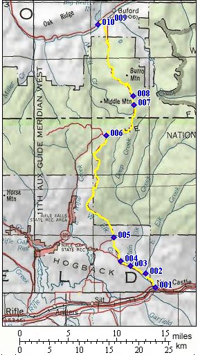
Buford - New Castle Road
summit(u)
This Forest Road summit is the
most aerobic way for a cyclist to cross the
White River Plateau, a densely forested,
unpopulated, high plateau between the Colorado
River and White River. The point of highest
altitude may also be reached by a variety of
smaller tracks. The last time I rode this, the
entire distance was a fairly smooth, hard dirt
surface without washboard (Oct/05). But these
things change. The summit is not named or marked on maps. But you do get the impression that you are embarking on a high summit road, from the road signs at the bottom of CR8, here named Flat Top Road, leaving Meeker. The Buford - New Castle road is included in the sign forest of the various open-closed signs for the dirt road passes, leaving the White River Valley near Meeker.
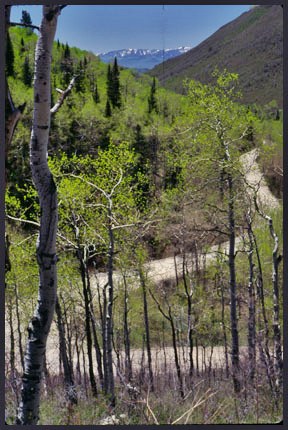
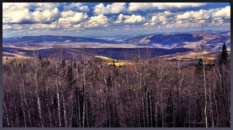
From South. After leaving New Castle, Buford Road diverts from the road to Harvey Gap, by taking a right turn and climbing towards the eastern edge of Grass Valley. The road leaves Grass Valley by following a densely forested side valley. Views of the Grand Hogback remain obscured behind a low ridge. After a persistent steep climb to the edge of the plateau, a vista on Roan Plateau opens to the west. I think this is the best view along the route, unless you take the time to explore long side routes. But the work out is far from over at this point. The plateau rolls along, but trends upwards. The highest point offers no grabbing views on the first take. But during a ride in late fall, Clark Ridge in the Flat Top Mountains (Plateaus) in the distance hints at its surpsingly high elevation. It appears in the form of a ruler straight hairline of snow on the horizon to the east. From South. (also described upwards) The
town of Buford is a small store, selling hunting
supplies, and lately supplies for other tourists,
things like gasoline, soda and potato chips. This
side is much more remote country, and very far
from thoroughfare traffic, like on I70 on the
other side. In the fall, passing drivers tend to
be clad in orange, so that nobody gets shot
without a chance to shoot back. This is hunting
central. The wildly curving road gives a few
glimpses of the maze of plateau cliffs in northern
Colorado, framed by trees along the road, as it
steadily climbs to the summit.
A Day on a 3 day tour with this point as
highest summit
|
 This road is named after its
two endpoints. This implies that there is not much
worth naming a road after in between. - Not
exactly the way I see it. The road is the "main
highway" across the White River Plateau; main
highway in a relative sort of way. It's a good
dirt road that can be cycled with a mountain bike
in a non-technichal aerobic way, the way you
would ride a road bike, the tires are just a bit
heavier.
This road is named after its
two endpoints. This implies that there is not much
worth naming a road after in between. - Not
exactly the way I see it. The road is the "main
highway" across the White River Plateau; main
highway in a relative sort of way. It's a good
dirt road that can be cycled with a mountain bike
in a non-technichal aerobic way, the way you
would ride a road bike, the tires are just a bit
heavier.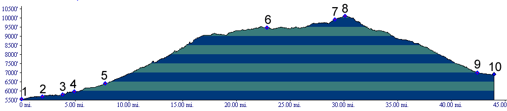
 Approaches
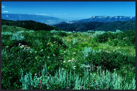
|
|
advertisement |
|
|
advertisement |