CR169 Waugh Mountain s(u)
This may be one mountain, you
probably never heard of, unless you are a rancher.
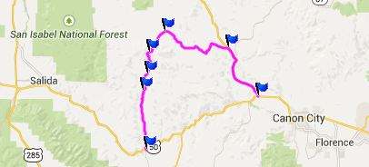
It is located north of Cotopaxi and the Arkansas
Canyon, south of South Park, east of Salida and
west of Co9 over Currant
Creek Pass. My de Lorme Gazeteer map shows
CR169 going all the way through, but the north
side is gated by the Stirrup Ranch
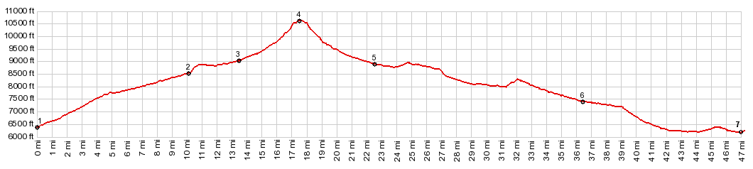 |
1.(mile00.0,6370ft)
START-END EAST: jct US50 - CR12 in
Cotopaxi on the Arkansas River
2.(mile10.1,8520ft)profile turns left from
CR12 onto CR16
3.(mile13.5,9020fit)route turns left onto
rougher Waugh Mtn Rd
4.(mile17.7,10620ft)TOP: CR169 WaughMtn
s(u)
5.(mile22.6,8900ft)jct with CR2; profile
turns right
6.(mile36.5,7410ft)profile turns right on
Co9 towards Canyon City
7.(mile46.9,6170ft) START-END WEST: jct
Co9 - US50, west of Canyon City |
 Approaches Approaches
From South. Picturesque
Cotopaxi is surrounded by Arkansas Canyon walls.
In the cool shade a four way intersection marks
the beginning point of the profile. CR12 heads
north. The first 1800ft of climbing are paved (a
sort of rolling paved), and there are no cars to
speak of. Turnoffs onto "Drives" hint at real
estate in the hills above, but none can be seen
from the road.
Soon after the pavement ends the road forks. The
profile stays right, climbing very steeply at
first, and then suddenly showing the objective
ahead at a flat section. From this point Waugh
Mountain looks like a big piece of flat bread. But
it's a workout anyway. The turnoff onto Waugh
Mountain Road is signed, but the letters have worn
off. To decipher what the sign says, you need to
investigate the sticky tape remnants on rotting
wood next to the road.
This jeep trail climbs into open ranching country,
crossing private property for about 3 miles (the
property next to the road is private, but the road
is public). The more open range land allows better
views. During morning hours the Sawatch and Sangre
de Cristo Ranges look like a single wavy board
against the frontal light. But you can make out
the low spot where Poncha
Pass separates the two ranges. The road soon
enters an aspen forest, and now climbs very
steepy, passing befuddled cows occasionally. It
was steep enough for me to walk once in a while.
The top is in a clearing at a coral and has an
nice view north. It should be better with late
light.
From North. (described
downwards). Over the top the road is very smooth.
But it deteriorates rapidly descending into the
aspen forest on the north side. Then a gate across
the road appears, maybe 500ft below the top. On
the other side, what was previously CR169
continues as abandoned road. It is fairly easy to
bike. The gate on the other side is crossed as
soon as the road emerges from the forest onto the
range land in South Park. Now a faint track
follows the property boundary around the Stirrup
Ranch, and connects to their access road.
Obviously there is no sign on this side.
Dayride with this point as highest summit:
PARTIALLY PAVED / UNPAVED
(< CR170
the Pines Ranch(sh) | CR1A Cotopaxi s(u)
>)
CR169 Waugh Mountain s(u) , CR12 Firebox
Road s(u) , CR2 Stirrup Ranch s(u) , CR37-CR1A
West Mc Coy Gulch(sh) : Mc Coy Gulch
<> 1.5 mile out and back with return because
I forgot something >> down CR37 West Mc Coy
Gulch > UW50 west > Cotopaxi > up CR12
> up CR169 > CR169 Waugh Mountain s(u) >
CR2 west > CR2 Stirrup Ranch s(u) > CR12
south > CR12 Firebox Rd s(u) > Cotopaxi >
up CR 1-A > CR1-A West Mc Coy Gulch(sh) >
back to starting point: 70.4miles with 7630ft of
climbing in 7:27hrs (VDO MC1.0 m5:14.9.13, t14_34)
CR169
Waugh Mountain s(u)
Highest Point: 10620ft
|
|
Eastern Approach:
|
climb |
over distance |
drop |
| jct US50 - CR12 in
Cotopaxi on the Arkansas River (6370ft) |
4250ft |
17+1/2 |
~100ft |
Western
Approach:
|
|
|
|
jct Co9 - US50, west of
Canyon City (6170ft)
|
4450ft |
29miles
|
~700ft |
|