| |
| |
CR2 California Gulch s(u)
The Mosquito Range, east of
Leadville, offers only one legal pass to bike
over, Mosquito Pass. It is said to be the
highest double track crossing in the state. But
there are a few other possible excursions into
this area, but they stay on the same side of the
ridge line, like CR2 up California Gulch. It is
paved from the north across the summit. The
southern side down Empire Gulch is a jeep road
of sorts.
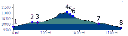
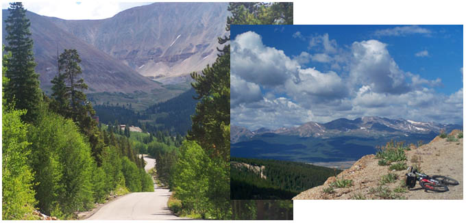
 Approaches From North. In order to get the most elevation gain on a pleasant road, the profile starts on the Arkansas River, between Leadville and Turquoise Lake. There are many ways to pick up California Gulch, east of Leadville. The profile shows the most direct route on city streets. A more pleasant option is to ride on the meticulously paved Mineral Belt bike path s(u). It crosses Co91 in Leadville at the Family Dollar Store, exiting town on the north side. This road is a sort of bicycle belt way around "the City" (if that's what you want to call Leadville). From it one can exit onto one of the various gulches, much like a commuter onto his work place. Unfortunately many of the exits aren't labeled, but the one up California Gulch is in a way. It is not a directional sign, but it is mentioned in one of the various overlook signs, offering small glimpses into the history of the area. Anyway, once you find it California Gulch begins
to climb quite climbs steeply after a while, on
nice pavement, with good views onto the Mosquito
Range, where it reaches a top. The wall to the
east is Mount Sherman, and the space it so
abruptly limits is named the Iowa Amphitheater.
From this vantage point it is difficult to believe
that this mountain is one of the easiest
fourteeners to climb, but most definitely not from
this side.
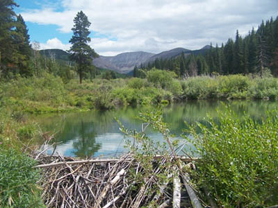
From South. (described downwards) After a short downhill, the luxurious pavement ends abruptly at the entrance to Iowa Gulch and its mining operations. The rest of the downhill is on a quickly bikable jeep road of sorts. The first left fork makes an interesting out and back ride up Empire Gulch. The first part of the road is on public access, even if the "no trespassing" signs next to the road are put up to negate that impression. However, Horseshoe Pass, another historic crossing almost as high as Mosquito Pass, cannot be reached over public access. Below this turnoff the road also follows Iowa
Gulch for a while, which then becomes Georgia
Gulch. Along the way the road passes an
engineering marvel, a beaver damn (picture
included). As Georgia Gulch approaches Leadville,
it crosses the commuter beltway (Mineral Belt bike
path s(u)). Sadly this turnoff is not
labeled, but it is the next crossing south of the
CR6 crossing to the village dump (excuse me -
landfill and recycling station, non covered loads
are charged double). Continuing across the belt
way, the road becomes CR6a, then CR6. The turnoff
to CR6 from Co91 is labeled with a landfill
directional sign. The profile continues down the
southern access road to Turquoise Lake to a low
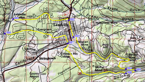
point. Dayride PARTIALLY PAVED / UNPAVED / SINGLE TRACK CR2 California Gulch s(u), CR9 Turquoise Lake s(u): jct southern Turquoise Lake Rd - Arkansas River > Leadville > CMC campus > up Elk Run Wheeler's Trail > north on Mineral Belt bike path > up CR2 California Gulch > CR2 Californa Gulch s(u) <> out and back loop up Empire Gulch and about 500ft above Paddock SWA >> down Iowa Gulch Gulch > down CR6A > down CR6 > northern access road to Turquoise Lake > Turquoise Lake s(u) <> out and back to every view point and lake access point, except campgrounds on eastern side > back to starting point, including a few additional out and backs: 46.9miles with 4450ft of climbing in 4:56hours. |
|
|
advertisement |
|
|
advertisement |