| |
| |
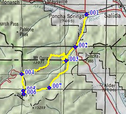
Colorado Trail m272.1(sh)
section: Marshall Pass - Silver
Creek
The best known biking portion of the Colorado Trail is probably the Monarch Crest Trail. But this section adjoining it to the south, is almost as popular. It can easily be cycled separately in a loop, without the need for motorized support.
From North. The profile starts in Poncha
Springs and starts to ascent Poncha Pass, then the
old railroad grade, now a dirt road to Marshall Pass. The
description starts here. The Marshall Pass parking lot is .2 miles east of
the summit. Taking a Here left here, up the
embankment, leads to another multi fanged fork (if
forks have fangs). The leftest of these fangs
descends Marshall Pass via Poncha Creek Road. The
rightest is the double track motorized version of
the route following the Continental Divide. We
want the middle, a single track containing the
joint routes of the Continental Divide Trail and
the Colorado Trail. A meticulously smooth track pleasantly ascends a
subalpine meadow. This is the first and only time,
that a view to the west opens up. Soon the smooth
trail enters the forest and rolls along, staying
just east of the divide. A short downhill leads to
the point where the motorized route and the CT
coexist on the same piece of land. Except for a
short uphill, all of this section is easily
rideable. It does not appear as steep as the
profile makes it look. After about 4 miles a view to the east and the
Sangre de Cristo Mountains opens up. This is a
signal that this short section of the Colorado
Trail is almost over. Staying on the Colorado
Trail here looks like a long and rough slog
direction Saguache. The view of the mountains also
shows the descending route at the bottom of a
steep rock cut, following Silver Creek. According
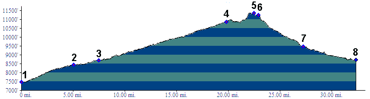
to the literature the highest point of the route
is at the turnoff down Silver Creek Trail. While
riding it, I had the impression that the highest
point was slightly before the summit. Drawing the
profile with topo software confirms this
impression.  From South. (described downwards). The
turnoff itself has another great view of the route
ahead, this time with very photogenic foreground.
It is the last great scenic panorama on this
route. Two or tree steep switchbacks lead through
a meadow to the bottom of the gulch. The trail
becomes rockier as it descends, especially when it
crosses the palisades, that looked so picturesque
from above. A first crossing of Silver Creek
signals the end of the single track. Here a
bikable ATV trail ascends to the right up Toll Road
Gulch. A little later you can also pick up
another single track, the Rainbow Trail, heading
direction Salida with detours. Following Silver Creek downstream a bit, you
wonder just where you took the wrong turn into
suburbia. A number of elaborate single family
housing projects line the dirt road verging on a
jeep track. Immediately afterwards the route turns
into a good dirt road. The profile follows Silver
Creek Road back down to its junction with the Poncha Pass Road.
Dayride with this point as highest summit: PARTIALLY PAVED / SINGLE TRACK (<FR400
Gardner Road s(u)|FR869 Toll
Road Gulch s(u)>)
|
 Approaches
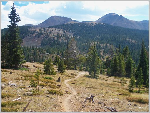
|
|
advertisement |
|
|
advertisement |