| |
| |
Marshall Pass
As the Sawatch Range approaches
its southern end, its peaks become lower and more
rounded. Its mountain passes also become lower and
historically older. Marshall Pass predates all
forms of the next crossing to the north, Monarch
Pass crossing.
Marshall Pass is 500ft lower and gentle enough for an old railroad grade. It is a much more peaceful ride on a good dirt road through a majestic mountain environment. Both sides can also be used to make a loop ride over the Monarch Crest Trail s(u), and also the Rainbow Trail The 14er Region Mountain Bike Guide ( a free publication, available at local businesses ) has included Marshall Pass in its map of recommended bike routes since at least 1994, even with a detailed description.
From East: In order to start at the
bottom, the profile starts at the bottom of paved
Poncha Pass.
The Marshall Pass route stays along Poncha
Creek, while the paved main road to Poncha Pass
diverts from the creek, whose name it shares. Once on CR200 (which becomes FR200 at an
indistinct point), signs for Marshall Pass
actually divert you away from the first part of
the railroad grade. But it's just as easy to
follow the railroad grade instead, actually easier
because it is flatter. Just stay left at the first
intersection, following signs for the site of
Shirley instead. At that point, follow a sign for
the Poncho Creek Road. Then after crossing the one
and only unmistakable bridge on the entire route,
the road following the railroad grade swoops back
towards the east in a unmistakable large railroad
radius curve. If there are still any doubts that
this is the old grade, the first rock cut should
make a convincing argument. These wildly curving switchbacks up the lower
slopes of Mount Ouray gain altitude slowly.
Instead they seam to exist for the pure joy of
curving. Could it be the road wants to pay homage
to nearby O'Haver Lake. No, it really
couldn't. A more rational explanation is the
historic background of the road as railroad grade.
On these early low meanders of the road, O'Haver Lake appears below, nestled between green ridges and backgrounded by last rounded mountains above treeline of the Sawatch Range. Then, and as you make your way along the long traverse, with the changing perspective, finally the Sangre de Cristo Mountains appear behind the lake. There are also many great vantage points onto Mount Ouray. I think it looks more impressive from below. Mount Ouray is a large cone with a prominent cirque eroded at its center, and a cross country ski objective in the winter (1st picture). The sight of a narrow gauge train on these bends
must have been something. With gained
altitude and many switchbacks later, the
appearance of Mount Ouray deteriorates to that of
a giant, bloated pancake while the Sangre de
Cristos take on a comb like appearance on the
other horizon. Mount Ouray is better viewed in
early morning light, while the Sangre de Cristos
are preferable in late light. That's one reason
for two different variations of cycling tours over
the pass, one east to west, another west to east.
The way to the summit summit leads through an
expansive mountain meadow and tops out at what
must be the most massive road cut (or rail cut) on
the continental divide. 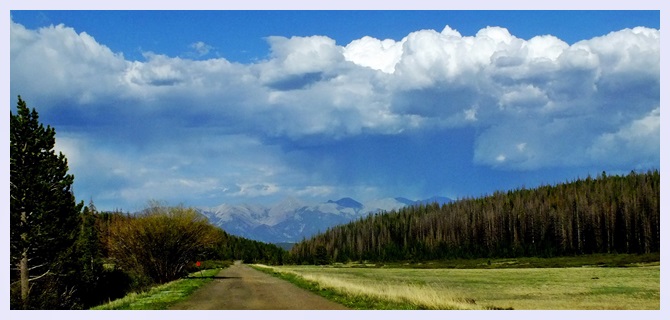 From West: (also described upwards) The
dirt road starts through sage hills, following
Marshall Creek into forested hills. This is a
pleasant, quiet ride. Only two or three times
triangular rock slopes appear between the canopy
of trees. Switchbacks seem to curve around the
summit even more than on the west side.
Approaching the summit the rocks on the sofar very
smooth road become just a little larger. The last
straight approach to the summit is dominated by a
view of comlex rouded hills above treeline. Is
this Windy Peak (11800ft) ? The top of the pass
shows up completely unexpectedly after a traverse,
ending with an unexpected 90 degree turn to the
left through aforementioned rail cut. Alternate Approaches Another option for the eastern approach is to
take the Poncho Creek Road instead. It is fairly
well behaved along the bottom. After the fork with
the Starvation Trail (yet another longer way to
approach the pass via a partial single track), the
road becomes increasingly more rocky and steeper.
There are none of the impressive views of Mount
Ouray or the Sangre de Cristo Range along this
route. There is really just one far view, located
near the top, just before the Starvation Trail
merges back into Poncho Road. A short, good
section of dirt road stays flat along the top to
connect with Marshall Pass. Dayrides with this point as intermediate
summit are on pages: Old Monarch Pass Dayrides with this point as shoulder
point are on pages: Monarch Crest
Trail s(u)
The history of Marshall Pass is a story of
railroads that didn't materialize, and others that
did so reluctantly. It is a story of struggles
between competing industrialists, and the battles
of track layers. However the first story told is
of a different nature. It's the story of a
toothache leading to the discovery of the pass, at
least as far as the official discovery is
concerned. In 1873 the Hayden survey was not the only survey
crew, to criss cross the Rockies. The army's
Wheeler survey was there too. As told in a story
by Marshall Spraque in "the Great Gates" : while
exploring in the San Juan mountains, Lietenant
William Marshall developed a toothache. The
conventional route separating a San Juan resident
from his dentist would have lead him over Cinnamon Pass, Cochetopa Pass,
and Mosca Pass,
onwards to dental chairs in Denver or another
Front Range city. Instead Marshall substituted
today's Gunnison Valley and the pass today bearing
his name for Cochetopa
Pass and Mosca
Pass, thus shortening the dental commute by
four days, according to his own estimate. The name
Marshall Pass proved itself infinitely more
persistent than a toothache. Gunnison Rail Survey (<Poncha Pass|Cochetopa Pass>) In 1853 the Gunnison Survey was tasked with exploring a feasible transcontinental railroad route through this part of the Rockies. The Gunnison survey noted Marshall Pass for its potential while crossing Poncha Pass back to San Luis Valley. But the survey did not cross Marshall Pass. The real objective of the Gunnison survey in this area was to study the suitability of Cochetopa Pass Still - Marshall Pass was eventually crossed by a
railroad, even if it was a different venture than
coast to coast. Marshall Pass is one of two
Colorado passes, not only initially noted by the
Gunnison rail survey, but eventually crossed by
rails, with a destination other than
transcontinental. More further below. The Leadville Boom Period (<
Old Monarch Pass
| Black Sage Pass
> ); also Otto Mears Passes (<Poncha Pass|Cotchetopa Pass>):
Twenty four years later, we find Captian
Gunnison's name attached to the valley of his
adventures and also its new town. As the mining
activity and the following wealth spread from
Leadville into the Gunnison valley, the town of
Gunnison emerged as regional center in its own
right. A wagon road was needed to the new
commercial center. There were two options Marshall
Pass or today's Old
Monarch Pass. Marshall Pass was a route
preferred by the people whose opinion counts in
these matters, the founders of Gunnison. They
exerted pressure on toll road operator
extraordinaire, Otto Mears, to improve the route
from a set of tracks, into a toll road in 1877.
Otto Mears was only too happy to oblige. His
exisiting toll road over Poncha Pass could use
a branch line, and it received one too.
Railroads (<Tennessee
Pass|Williams
Pass>): The story of railroads over
Marshall Pass parallels the story of Otto Mears
wagon road over the pass. In both cases the
objective was to supply the growing boom town of
Gunnison. But it also features two other elements,
a monster tunneling battle and the secrect
agreements of capitalists to circumnavigate the
forces of competition.
The two railroad bosses had divided up the
Arkansas valley neatly between them. The DRG could
gouge prices in Leadville, and the DSP benefited
from Buena Vista. DRG's Palmer had promised DSP's
Evans not to build a line over Marshall Pass to
compete with the DSP's plans to reach Gunnison
over a very difficult route. The DSP was engaged
in a major tunneling struggle to cross the Sawatch
Range under Williams
Pass, the Alpine Tunnel. The tunnel battle
was not going well for the DSP. DSP's Evans
eventually capitulated and was about the sell the
railroad to the most corrupt railroad capitalist
of the period, the UP's Jay Gould. Now DRG's
Palmer considered his promise not to compete for
the Gunnison Basin ore traffic null and void. It
was made to John Evans personally. The promise was
not transferrable to Jay Gould of the UP. Between 1880 and 1883, the DRG employed a work
force bigger than the US army in its effort to lay
tracks across the top of Marshall Pass. While the
DSP had spent two years on their tunnel project in
the Sawatch Range, the DRG had comparatively easy
going. Instead of a tunnel, but the DRG still
needed 23 snowsheds to keep the line open during
winter. The DRG entered Gunnison on August 8/81.
To see how the DSP fared, this thread continues on
the Williams
Pass. The top of Marshall Pass even had a station with
a post office. Unlike the DRG main line through
the Arkansas valley, the Marshall Pass route
remained narrow gauge until operations ended in
1952. The rail were salvaged three years later.
Modern Highways(<Poncha
Pass|Old
Monarch Pass>) Prior to 1922 Marshall
Pass was considered the main highway connecting
the Arkansas Valley with Gunnison. Then familiar
question came up again. What's the best way to get
to Gunnison ? The mode of tranportation du jour
was now the automobile. The choice was between
Marshall Pass and a route over Old Monarch Pass,
which was not called old at the time. This time
the opions, that mattered most, were those of the
highway department. It favored Old Monarch Pass.
Still, both routes persisited. When road names
where changed to numbers in the 1930s, US50 was
designated over Old
Monarch Pass and the importance of Marshall
Pass declined. The latest human venture through
the top of Marshall Pass is a gas pipeline, built
in the 1960s. Cycling. An early mountain biking guide,
first published in 1987 mentioned Marshall Pass as
being suitable for mountain biking in its
appendix, without describing it any further
(William L. Stoehr's: Bicycling the Backcountry).
|
 Principal Approaches
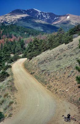 History
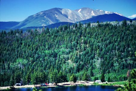 This is the rail situation so far
: It was several links back in this thread that we
last saw the Denver South Park railroad (DSP)
reach the Arkansas Valley via
This is the rail situation so far
: It was several links back in this thread that we
last saw the Denver South Park railroad (DSP)
reach the Arkansas Valley via |
|
advertisement |
|
|
advertisement |