| |
| |
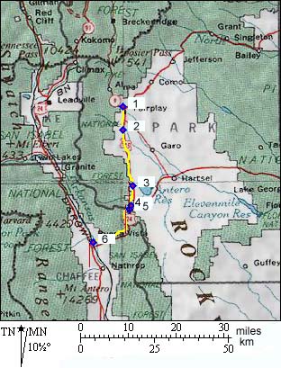
Trout Creek Pass
Trout Creek Pass is the easy exit
from South Park on the west side. Despite the lack
of a big climb, the pass marks a major separation
of drainages, not between the Atlantic and the
Pacific, but still major. Water falling on the
arid high plains of South Park eventually ends up
in the South Platte. Rain to the west falls into
the valley of the Arkanasas (heading for the state
Arkansas). Not until a couple of hundred miles
north of New Orleans, that a split rain drop,
falling on top of the pass, finds itself
theoretically reunited in the Mississippi River.
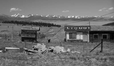
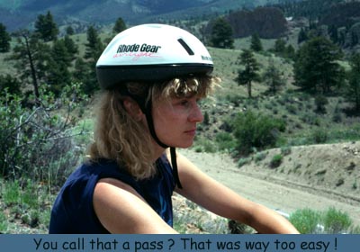
This used to be a great bike ride and a scenically fascinating experience in a "big sky kind of way", especially heading east to west. The route marks the exit from the highest of Colorado's dry mountain parks, and rolls down to the foot of the 14 thousand foot spine of the continent int the valley of the Arkansas. Presently much of the shoulder contains some rumble strips and traffic is so heavy that it is advisable to choose the time to cross very carefully.
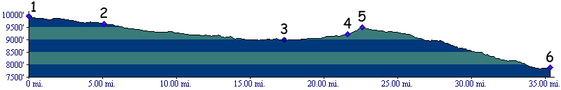
From East. The starting point of the
profile is actually at a higher elevation than the
top of the pass, and the starting point is still
in South Park. Still, there is a discernible climb
over 500ft between the low point and the top. As you leave South Park the shoulder begins to
have rumble strips (June 2011). They leave just
barely enough room to cycle to the right of them,
unless you are towing a trailer or don't like
rocks and sand - or unless you are going downhill.
The only safe spots are where the rumble strips
have been discontinued, apparently because of the
presence of a guard rail. ( Yes - I suppose
crashing into the guard rail would also wake up
sleeping drivers) From West. (also described upwards)
Heading away from Johnson Village, the road soon
enters sandstone bluffs and low rocky ridges.
There are great views of Mount Princeton
(14197ft), Mount Yale (14194ft) and Mount Harvard
(14420ft), obtainable from a small distance
off the main road, before the highway surrounds
itself with low hills. The pass crossing itself
offers no views, and is really perceived as part
of South Park. There are no rumble strips on this side, but also
barely a shoulder that could hold them. Traffic
can be dangerous during vacation or holidays.
Trout Creek Pass is historically the exit of
South Park. The pioneers who crossed, always were
searching for something. Pike was looking for the
Red River - not very good prospects of finding it
here. Miners were searching for gold. They had
better luck. Railroads were looking for business.
They too, found what they were looking for, but
not for long. Pike (<Currant Creek
Pass|Medano
Pass>): The pass was crossed by Pike
during his futile search for the Red River. He
arrived in the winter of 1806 by way of Currant Creek Pass.
Having mistaken Currant Creek for the Arkansas, he
concluded that the Arkansas ended on the east side
of the pass. Still on the same side, he
found another river just a few miles away. From
previous visits with Pawnee Indians, he concluded
the river was part of the Platte drainage. He was
right about the Platte, but wrong about the
Arkansas. Pike's correct identification of the
Platte drainage is remarkable, considering the
geographic misconceptions of the time, such as
expecting the Yellowstone drainage just over a
pass to the north. Pike was right about the
Platte, wrong about the Arkansas, and still
looking for the Red. Rather than looking for the Red River where it
exited the Rockies, he expected to find it further
west. Consequently he traversed South Park, and
found the shallow gap in the Mosquito Range to
lead him down to his "Red River Valley". At least
that was what he hoped for. Ironically his Red
River was the Arkansas, which he had previously
attempted to follow to its source, but went up
Currant Creek instead. But Pike did not know that
yet. To him, it was the Red, at least for now. If
all that seems confusing, just think how Pike must
have felt. Pike and company moved up and down the Arkansas
(their Red River) valley during that cold winter,
noting many passes, but staying busy just trying
to staying alive. Their mission was accomplished -
Red found. They proceeded down it in dugout
canoes. Several days later the canyon became to
difficult to navigate, and Pike by himself climbed
a nearby peak to get the lay of the land. It was
Noonans Peak, and below it was their old camp on
the Arkansas, when they still were right about
being on the Arkansas. That must have been quite a shock ! Rather than
return to east of the mountains, Pike's
wrecklessness and disregard for the life of his
companions led him to continue the search for the
Red in the mountains. He built a block house at
the old Canyon City Camp Site, and then headed up
the Arkansas again, the identity of which he had
so painfully discovered. They were not equipped
for the winter. Pike had the only hat in the
group. The rest wore breachcloth, slabs of buffalo
hides for shoes, no stockings, the rest made up of
deerskin, blankets and bits of canvas. In this
condition they reached the Wet Mountain Valley
near present day West Cliff. They spent a horrible
January camped near the Promontory Divide, near
present day Westcliffe, and then explored Medano Pass.
Fremont (<Currant Creek
Pass|Tennessee
Pass>): Professional hero of manifest
destiny, Charles Fremont, also crossed Trout Creek
Pass, albeit in a hurry. During his third
expedition, the primary objective of finding
military and emigration routes for westward
expansion had been replaced by the more urgent
objective of military action in California. But
rather than taking the Oregon Trail route, Fremont
opted for Pike's old route over Trout Creek Pass.
From there Fremont's route diverted north,
leading to an official discovery Tennessee Pass.
Colorado
Gold Rush of 1859/60(<Currant Creek
Pass|Red Hill
Pass>): Digging for gold in South Park
was all the rage in South Park in 1859. Currant Creek Pass
was one of the passes used to enter South Park.
Trout Creek Pass was also one of the first passes
used to move on, in search of more colorful hills
promising more precious metal. Once in the
Arkansas valley, they were less impressed with the
magnificence of their suroundings than the gold
they found to the north as far as the Twin Lakes
area.
Railroads(<Kenosha Pass|Fremont Pass>):
Trout Creek Pass was crossed by the Denver and
South Park (DSP) railroad after they had
entered South Park over Kenosha Pass. The
race to the next pot of gold was Leadville. The
race had two participants: the pass climbing DSP
and the valley railroad, the Denver Rio Grande
(DRG), which built its line up from Canon City. Once across Trout Creek Pass, the DSP was in the
same valley as Leadville, and it still lost the
race. You could build and engineer as hard as you
might, the real decisions were still made by the
mogul owners. UP's Jay Gould managed to obtain a
right of way to Leadville and gave it to DRG, as a
reward for keeping a bigger enemy, the SF (Santa
Fe), out of Royal Gorge. It would be the last time
the DRG would obtain a favor from the corrupt boss
of the UP, Jay Gould. The Arkansas valley was now serviced by two railroads. The DSP and DRG had managed to divide the valley between themselves. Both of the railroads were narrow gauge lines. But in other aspects they coudn't have been more different. The DRG's route was a stretched southern bow. It traversed the rugged Arkansas canyon. It was the first railroad to cross a Colorado pass, but after that stayed low in the valleys. The DSP's route was a direct shot from Denver to Leadville, reasonably direct anyway, not over Loveland Pass, but over Kenosha and Trout Creek. The destiny of the brave little DSP was to forever to cling to the cliffs above the riches The DSP line over two passes was a preparation
for bigger things to come. The railroad had its
sights set on the next pot of gold, the ore
traffic from the Gunnison Basin. The DSP started
building a line up direction Williams Pass to
the mining towns Saint Elmo and Hancock, direction
Gunnison. But before the tracks managed to
overcome the mighty Sawatch Range, two years would
go by, and a lot of valley rail would be hammered
into place. In the end, the valley routes won out.
The DRG also won the race to Gunnison. But
following the passes in chronological order, we
have to go back to the beginning of the previous
paragraph, the time when the DRG won its first big
race, the competition to lay track to Leadville. While the DSP was engaged in a two year struggle to tunnel through the Sawatch Range below Williams and Altman Pass, new DRG tracks crossed less challenging passes to feed business into Leadville. One of them is Fremont Pass. (<Ute
Pass|Hagerman
Pass>) Later Trout Creek Pass was crossed
again, this time by a standard gauge railroad on
its way from Colorado Springs to Leadville. The
DRG had grown to monopolize the Colorado railroad
traffic, and this line was an attempt to break the
monopoly. Hagerman's Colorado Midland railroad
reached Leadville by the end of the summer of
1887. From there his rails pointed west to a new
crossing of the Sawatch Range, up Hagerman Pass. Cycling-Ride the Rockies:(<Hoosier Pass|Independence
Pass>): Between 1986 and 2005 Trout
Creek Pass has been crossed once by the Denver
Post's "Ride the Rockies", during 87, on a
stage between Buena Vista and Breckenridge,
which also included Hoosier Pass.
The previous day crossed Monarch Pass,
while the following day was spent riding over
Loveland Pass.
The links under this heading follow passes in
order of how often they have been crossed by
the Denver Post sponsored ride.
|
|||||||||||||||||||||||||||||||||||||||||||||||
 Approaches
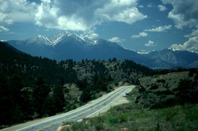
|
|
advertisement |
|
|
advertisement |