| |
| |
Cordova Pass
The Spanish Peaks are unique set
of mountains, especially for Colorado. Their cone
shape speak of volcanic activity. But there are no
craters on top, even if it may look like it from a
few locations below. These volcanic features
originated under the sea and never erupted.
Instead molten volcanic magma collected in two
bulges. Cracks developed in the surrounding rocks.
Magma filled these craks, and after erosion did
its job, today dikes radiate outward from these
ancient undersea bulges like spokes on a bicycle
wheels. Since the magma was more difficult to
erode than the surrounding sedimentary rocks. they
lie exposed today.
Two pass roads go near the peaks, this one and Cucharas Pass, which also serves as approach to the west side of this pass. Much of the beauty of Cordova Pass is in its isolation. The views of the peaks and the dykes radiating out from them are really better from the La Veta - Cucharas Pass section, that is the paved lower western side of the approach.
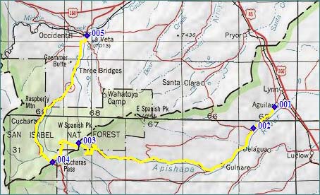 Approaches From West. For some notes on the section
La Veta - Cucharas Pass, see the Cucharas Pass page.
From the top of Cucharas Pass a good dirt road
takes off to the east across a high meadow. It
heads for the forest. The Spanish Peaks are not
really visible from here. After 2 or 3 level miles
the road begins to climb. The trees break open
twice to reveal a partial view of West Spanish
Peak. No switchbacks and just limited turns are
required to get to the summit. There still aren't
any far views from the summit either. Instead
there is a pay campground, a trailhead, and two
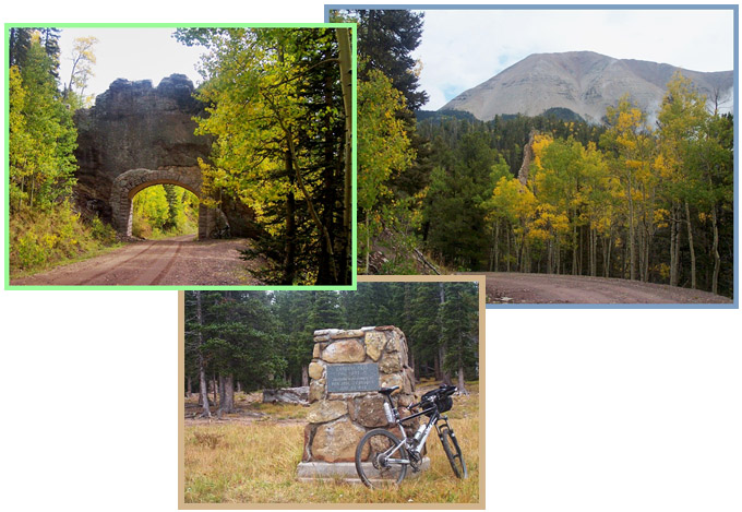
summit markers. Interestingly they differ in
elevation. The older, more elaborate monument made
from natural stone with plaque commemorating Jose
Cordova states an elevation of 11005ft. The newer
generic national forest sign says 11248ft. Hiking .2miles to the south gets to a good
vantage point on the peak. For a mountain bike it
would be no effort at all on this smooth, flat
handicap accessible thoroughfare. But where
bicycles are grouped with ATVs (like here) this is
not a legal option. From East. (described downwards) The road
continues in the forest in a westerly direction.
On the south side of East Spanish Peak it finally
engages in a few extra turns, still with only
limited views of the peak and several dikes
through the trees. A interesting curiosity is an a
tunnel or arch that has been cut through one of
the dikes to accomadate the road. Now leaving
behind the peak the road heads about as straight
west as the landscape will allow. After the first
ranch below the peaks, the road becomes as wide as
interstate highway for a while, but the surface
remains various variations of dirt, but with
little if any washboard. The peaks are now a decoration at the horizon to
the back, possibly with monumental clouds above
them. The road becomes a fast dirt road, passing
through Gulnare, a collection of ramshackle
housings that not only sound but also look new
Mexican. Apishapa Canyon too, fits the New Mexican
definition of a canyon better - it's just a small
valley bordered by low ravines. Finally the long
dirt road treck ends in Aguilar, a nice sleepy
town with a collection of buildings on main street
that speak of past importance. It even has a small
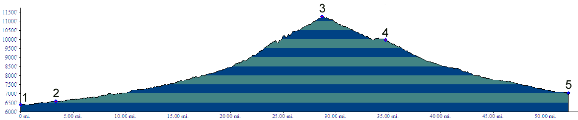
grocery store of sorts. Dayrides with this point as highest summit Cordova Pass: CR46.0 south of Aguilar > CR46.0 south > Cordova Pass > Cucharas Pass(shp) > Cuchara > La Veta > Co12 > US160 east > Walsenburg > I25 south > CR53.7 south > Aguilar > CR46.0 west back to starting point: 87 miles. (m1:91.05.29) ( < FR401
Deer Peak Rd s(u) | Cucharas Pass >
) History Modern Roads. If this route was used by
nomadic Indians and/or Spanish traders is
speculation. But this is one road, the existence
of which is not due to a group of people seeking
riches from minerals, but the persistence of a
single man, the Las Animas county commissioner
Jose Cordova. The road was finished in 1934. In
1942 its official name became "Apishapa", Apache
for the "stinking water" in Apishapa Canyon on the
lower eastern side of the pass. The name Cordova
was officially attached by the USGS board on
geographic names in 1978. Cycling. An early mountain biking guide, first published in 1987, mentions Cordova Pass as being suitable for mountain biking in its appendix, without describing it any further (William L. Stoehr's: Bicycling the Backcountry).
|
||||||||||||||||||||||||||||||||||||||||||||||
|
|
advertisement |
|
|
advertisement |