| |
| |
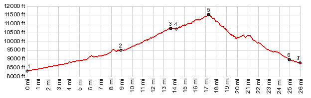
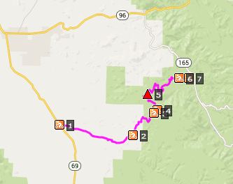
FR401 Deer Peak s(u)
I heard somebody remark once,
that god put the Wet Mountain Range in this
place, so that man might have a better view
onto the Sangre de Cristo Mountains. There are
many points on top of the range (or plateau),
where one can form an opinion about this
statement. The most obvious one is FR400
Gardner Road s(u). The approach to the
FR401 Deer Peak summit, crosses that point and
then reaches a little higher. This is more of
a jeep trail summit, while most of the Gardner
Rd summit (with some exceptions on the east
side) is a smoother dirt road.
The profile turns south and
follows a jeep trail, starting out as a regular
dirt road but climbing steeply. It stays in
forest until it reaches a summit meadow close to
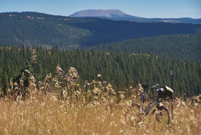
a transmitter facility. From here you can can
see the single bare outcrop in the Green
Mountains, marking its southern end of the
Green Mountains, Cuerno Verde or Greenhorn Mtn.
There is a way to continue straight from here,
but the profile remains on FR401, turning right
steeply uphill - a short walk can be refreshing
after all that rock and roll - and crests when
passing near towers of the transmission
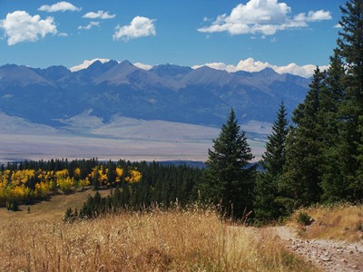
facility. The view from this meadow stretches
from Greenhorn Mtn, to the Spanish Peaks, and
over the southern end of the Sangre de Cristo
Range. But all these peaks are pretty far away
and when there is no snow on them they are bound
to look a bit hazy by the time one arrives on
top, even in late September when the leaves are
changing.
At the first intersection CR401
ends and only another option continuing straight
is signed. The better road crossing here is not
signed. My directional sense told me turn left,
but the profile takes the correct option which
is right and downhill. The road slowly becomes
faster and continues to curve around, so that
it's easy to loose a sense of direction. The
road finally reaches hard top on Co165 between
at the bottom between the Bigelow Divide to
the north and the Greenhill
Divide to the south. Dayride with this point as
highest summit PARIALLY PAVED / UNPAVED ( < CR1A Cotopax(sh)
| Cordova Pass
> )
- |
||||||||||||||||||||||||||||||||||||||||||||
|
|
advertisement |
|
|
advertisement |