| |
| |
Cumberland Pass
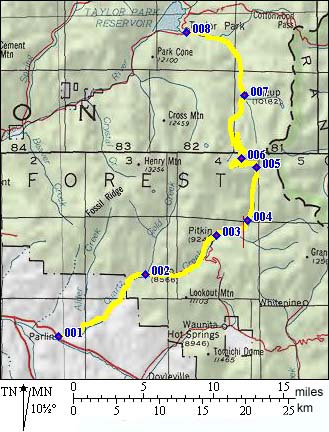
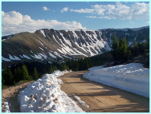
Cumberland Pass is a dirt road, climbing over an outlier of the Sawatch Range. The grade is uniform, and the surface is often not so great for riding a bicycle. The road is used by regular passenger cars, and can be sandy and resemble a washboard. The best time to ride it is when it hasn't been maintained for the longest. "Maintaining" means adding sand and running a grader over it. "Maintenance" does make it easier for passenger cars. But for a bike it may means that you have to ride in first gear before the climb even starts. The top is a great vantage point onto Taylor Park and the Sawatch Range. But to get the full scenic impact, you have to include a 5 minute walk from the pass onto one of the surrounding hills.
 Approaches Approaches
From South. The road between Parlin and
Pitkin is paved and makes a pleasant valley road
ride through interesting rock formations. From
points to the east, there is a dirt road cutoff
from US50, leading through a BLM area of
interesting rock formations. Past Pitkin a quiet forest road slowly, but
steadfastly gains elevation. After ample peaceful
riding, the first abrupt 90 degree left turn
indicates a change. From here long ramps connected
by switchbacks are about to start, even though the
slope gets gentler, but just momentarily. Climbing
towards paradoxically named "Green Mountain"
- much of it is sheer rock, the treeline
draws ever nearer. The final long traverse reaches
above the trees. The best view is to the back,
especially in late afternoon light. The big
amphitheater below Green Mountain slowly sinks
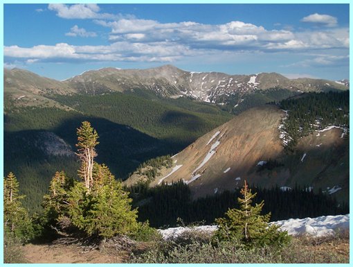
into deep shadows. At the top, low hills block much of the view to the west. The view of the Sawatch Range main ridge too is truncated by a small nearby rounded hill. If time and energy remains, both sides can be quickly climbed on foot to get a complete overview of the landscape. Some of the pictures with this page are taken from these hills.
From North. (described downwards) A
long traverse gives a last chance to enjoy a far
view of the Collegiate Peaks of the Sawatch Range.
The more southerly part of the range is slowly
eclipsed by the ridge the road has just crossed.
After a first long traverse the road switches back
and Willow Creek, meandering in endless S
patterns, as a swampy valley below slowly draws
closer. More long traverses connected by
switchbacks follow and the road joins the creek in
a final shallow descend through a pleasant bush
filled valley into Tincup. This old historic mining town remains cut off
from modern distractions, unless it is the fourth
of July weekend, when hoards of ATVs descend onto
the town. The road from Tincup to Taylor Reservoir
is a wide, often sandy dirt road. with Plumes of
dust anounce the approach of motorized vehicles,
miles before they arive. The right end of the
profile connects to the Taylor
Pass profile, and the start of the eastern
end of Cottonwood
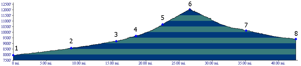
Pass is not far either. Dayride with this point as highest summit: PARTIALLY PAVED / UNPAVED / HIKE AND BIKE TRAIL: Notes: the other pass on this loop is only 10ft lower and takes much longer to get across.
A day on a Three Day Tour with this point as
highest point: (<Pearl Pass , Ohio Pass | ) A day to on Two Day Tour with this point as
intermediate summit is on page:
History The Leadville Boom (<Tincup Pass|Cottonwood
Pass>) Like many of Colorado's high
mountain passes, Cumberland's story revolves
around getting mining supplies to mining
towns. The time was the late 1880s. Everything
seemed possible. The sky was the limit. Riches
were just around the corner - sort of like the
early days of the internet. The mining town
Tincup was about to strike it rich. Maybe you
never heard of Tincup, even though you have
probably heard of other mining towns like
Aspen and Leadville. These mining towns of the
19th century are indicated in large lettering
on today's map, Aspen, Leadville, Silverton.
You have to search for Tincup with a
magnifying glass. Bicycling through it means
rediscovering one of the greatest little
isolated collection of cabins this state has
to offer. Anyway, Tincup's miners needed supplies. Over the years there were three competing roads to supply the miners of Tincup. One was short and difficult, Tincup Pass. Another one was quite a bit longer: Cottonwood Pass also crossed over the main range of the Sawatch to a railhead in Buena Vista. In Then around 1880, thanks to the cracy Denver, South Park and Pacific Railroad and its Alpine Tunnel project, a new railhead reached Pitkin. For Tincup, all that was needed, was a pass over this outlier of the Sawatch Range, and the shortest, and this would be the shortest, most practical connection to the outside world. But it still had to climb to over 12000 feet, just like the Tincup and Cottonwood pass roads. Compared with the other two options, this newest route, Cumberland Pass, was comparatively long and easy, but still shorter than the Cottonwood Pass option. Modern Highways.
The first report of a car crossing the pass
dates back to 1905. The car was pulled by
horses. More conventional, later crossings
apparently did not get the medias's attention.
By WW1, Pitkin was already history, so to
speak, and a map of 1919 does not show it. But
in 1935 the road was considered important
enough that the CCC was employed to improve
it. Further improvements were made in the mid
1950s.
Cycling. An early mountain biking guide, first published in 1987 mentioned Cumberland Pass as being suitable for mountain biking in its appendix, without describing it any further (William L. Stoehr's: Bicycling the Backcountry).
|
|
|
advertisement |
|
|
advertisement |