| |
| |
FR890 Round Mountain(sh)
The southern end of the Sawatch
Range looks much different than the chain of
14ers, that most people think of first, when
hearing the name "Sawatch". Here, north of the
town "Saquache" (different spelling, but same
origin), many parts of the range resembles a piece
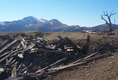
of Swiss cheese. All the countless holes were dug
by miners.
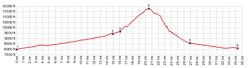
This loop over Round Mtn is designated as an ATV trail. The east-1 side is still relatively ridable. But much of the east-2 side is at best walkable. The main attraction for me is an interesting view point at the summit. The top is really the only point above tree line along this route. But you can get to higher, scenically magnificent points from there, if there is energy left.
Much of this approach is ridable, even if I
walked more than 50 percent. The double track
trail seems to aim for a high bare lip on a ridge,
that is just barely visible above the trees: Burnt
Mountain. But then at the first mine the road
changes direction by 90 degrees and traverses
north, now much flatter and easily ridable. Then
it switches to the east again climbing steeply.
When it begins to traverse in a northerly
direction a second time, the top is near. The top is a meadow at just about treeline. The
northern Sangre de Cristo Range becomes visible.
But the better views are a short walk (or maybe
even ride) away, a few hundred feet north from a
small knoll, that is surrounded by mining debris:
Round Mountain. From the top the 360 degree
panorama takes in: Mount Antora, Mount Ouray, then
the northern end of the 14ers in the Sawatch
Range, the Arkansas Valley, Poncha Pass, and the
Sangre de Cristo Range stretching to the Blanca
Massif in the south. Completing the 360 degree
view, there is a also a close by green ridge with
a trail on it, directly to the south. You can get
a bike up there too, but it does involve a lot of
walking. I can't find this trail on any maps (but
I call it Burnt Mountain summit -still
working on that page).
The road emerges into a clearing quite a distance
below Poncha Pass,
passing between large groups of aspen trees. The
last several miles are a smooth dirt surface. The
point, where the Alder Gulch Road (as FR890 is
called on this side) turns off US285 is not signed
on the highway. But once you go up the small
inconspicuous path for several hundred feet, a
sign states "FR890 Bonanza : 'several miles' ". 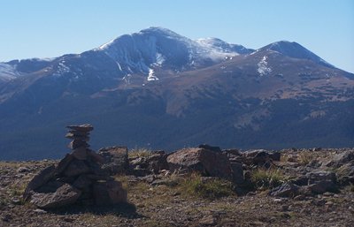 Dayride with this point as
highest summit: Dayride with this point as
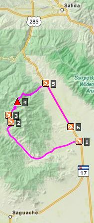
highest summit:PARTIALLY PAVED / UNPAVED (<FR611 Alder Creek(sh) | >) FR890 Round Mountain, additional out and back: Forest boundary on NN56 > down NN56 > US285 south > LL56 west > Bonanza > up FR892 > up FR890 > FR890 Round Mountain(sh) > down FR890 > US285 south > NN56 west back to starting point: 43.3miles with 4370ft of climbing in 5:24hrs (VDO MC1.0 m5:14.10.5) Notes: rear tube exploded on the way down, due to a gash in the tire. Otherwise a wonderful and amazingly warm, cloudless day in October
|
||||||||||||||||||||||||||||||||||||||||||||||||||||||
|
|
advertisement |
|
|
advertisement |