| |
| |
Gunsight Pass
A locally available map, the
"Crested Butte Summer Map with Trails, Streets
and Bus Routes", describes Gunsight Pass as a
"most difficult" mountain bike route, with
walking and bike pushing. This is not a
technical trail. It is an old mining road
reaching to over 12000 ft. You can see the
switchbacks from many of the single track
summits in the area - far away and still above.
The Crested Butte map does not mention the
southern approach.
Gunsight Pass requires a lot of
walking because it's very rocky. But you do get
to ride the bike once in a while. This may be
the most overlooked pass road in Colorado over
12000 feet. One reason is its south side, which
is often washed out and crosses land controlled
by mining claims. Another reason is
historic. Even when it was used, this was
a local road. The only purpose of this high
crossing was to provide local mining access,
rather than connect entire regions. The northern
approach is easy to locate. The other side is
full of gates, mining areas and dead ends. On
the way down it all falls into place more
easily.
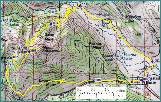 Approaches From North. The approach begins in the old
village of Crested Butte and continues up Slate
River Road. On this road the turnoff to the pass
is marked. Past the pedestrian bridge over the
river the track is a smoothly surfaced double
track. But this only lasts a short while, till a
small MTB loop diverts from the pass trail.
From South. (described downwards) There
are many options. But there are even more spurs
that end at dilapidated mining areas or locked
gates. Going downhill, this all seems less
problematic, than uphill. All valley routes
eventually lead to the Kebler
Pass road. Crossing a gate towards a road on
the other side of it, seems much less problematic
than starting to make ones way up it..
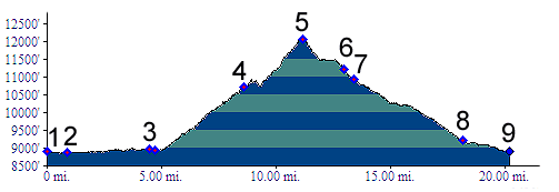
Dayride with this point as highest summit: PARTIALLY UNPAVED / SINGLE TRACK Gunsight Pass , Kebler Pass
x2 : campsite near
Marcellina Mountain on the western approach of
Kebler Pass > CR12 east > Kebler Pass >
Crested Butte > up Slate River Rd > Gunsight
Pass > down southern approach > CR12
west > back to starting point near Marcellina
Mountain: 55 miles with 6700ft of climbing in 8.3
hours. (m3:06.09..03)
Cycling: An early mountain biking guide, first published in 1987 mentioned this Gunsight Pass as being suitable for mountain biking in its appendix, without describing it any further (William L. Stoehr's: Bicycling the Backcountry). |
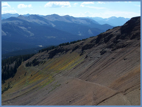
 The
innumerable switchbacks, that finally lead hikers
and cyclists to the summit, could be summed up in
three categories. First: progress is measured
against the vista of Mount Crested Butte
(12163ft), a triangle cliffs, remeniscent of fish
scales, located just behind the ski resort. At the
end of this section an uphill to the left leads to
a closed mining area. Second: Getting ever
rockier, the vista switches to the high northern
valleys, dropping off the Ruby Range. You can make
out the
The
innumerable switchbacks, that finally lead hikers
and cyclists to the summit, could be summed up in
three categories. First: progress is measured
against the vista of Mount Crested Butte
(12163ft), a triangle cliffs, remeniscent of fish
scales, located just behind the ski resort. At the
end of this section an uphill to the left leads to
a closed mining area. Second: Getting ever
rockier, the vista switches to the high northern
valleys, dropping off the Ruby Range. You can make
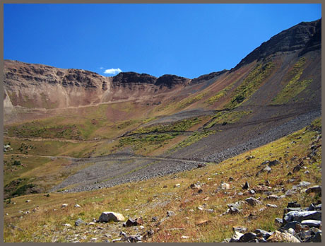
out the 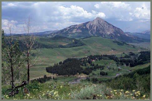 But back to the top. The
walking is not yet over. The rough, rocky track is
less defined on this side and repeatedly
interrupted by deep ravines, that have eroded the
path. Just where the trail goes out of view from
the summit, conditions improve dramatically. From
here a short uphill section leads to an equally
short single track. Then a junction forces a
choice, downhill on a smooth dirt road, or
continue traversing on the trail. It is possible
to keep traversing on the trail, while keeping
a look out for Lake Copley. But the smooth
dirt road is more direct and shown in the profile.
It leads past more mining debris to a locked gate
(without public access), across a mining area.
This road connects to the
But back to the top. The
walking is not yet over. The rough, rocky track is
less defined on this side and repeatedly
interrupted by deep ravines, that have eroded the
path. Just where the trail goes out of view from
the summit, conditions improve dramatically. From
here a short uphill section leads to an equally
short single track. Then a junction forces a
choice, downhill on a smooth dirt road, or
continue traversing on the trail. It is possible
to keep traversing on the trail, while keeping
a look out for Lake Copley. But the smooth
dirt road is more direct and shown in the profile.
It leads past more mining debris to a locked gate
(without public access), across a mining area.
This road connects to the |
|
advertisement |
|
|
advertisement |