| |
| |
Kebler Pass
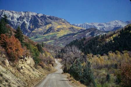
Kebler Pass is a very scenic dirt road through the West Elk Mountains. In the summer it is well maintained for passenger car traffic, since it is an important connection between Crested Butte and points north, such as the I70 corridor. In the winter it's closed. Depending on maintenance, the road can have quite a bit of washboard surface, but as a whole is very rideable in an aerobic style. I don't know any Colorado Pass that has more colorful Aspen than the western approach to Kebler Pass.
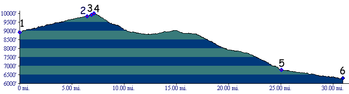
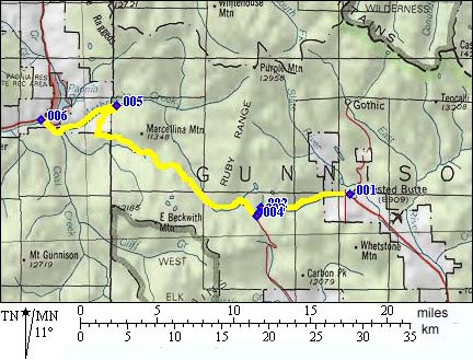
From West. Between points 5 and 6 the road follows Anthracite Creek. After a short paved section, the first real climb begins. You are rewarded with a magnificent view of the Ragged Mountains. The scenic variety along the rest of the climb is unsurpassed. Sometimes it's the cirques of the Ruby Range ahead, at others it's the peaks of the West Elks to the west. The curve below Marcellina Mountain is the most popular stopping point for views to west and south, during some fall weeks across a sea of yellow aspen trees. The route flattens for several miles, even goes downhill, and then buries itself in the aspen forest. It remains in the trees while crossing the top. From East. The climb is short, as steady as they come and in the trees. As of at least July/05 the initial miles leaving Crested Butte are paved. The rest of the approach is a hard medalled surface that is also suitable to a degree for road bikes. The same route serves as approach to Ohio Pass. The turnoff is almost at the top of Kebler Pass. A Day on a Two Day Tour with this point as the
highest summit: PARTIALLY PAVED/UNPAVED (<Schofield Pass|)
History Kebler Pass and Ohio
Pass were part of the Ute Trail network. The
trail connected the area of the present town of
Gunnison to the White River Valley near Rangely.
If you would follow this trail today, you would
start in Gunnison and cross Ohio and Kebler
Passes. You would turn onto Rte 133 towards McLure
Pass. Ride a little more than halfways up the pass
and then head up East Muddy Creek to cross the 10
to 11 thousand foot high plateau, separating
the valley of the North Gunnison from the valley
of the Colorado. From Silt you follow the Colorado
downstream to de Beque. The route goes up Roan
Creek and connects to Douglas
Pass. From there it decends along Rte 139 to
Rangely and the White River. Later both Kebler and Ohio passes served as a
supply route for a short lived gold and silver
boom near their summits, lasting till 1885. Back
then Ohio Pass was
the more important supply route. It had a stage
line as well as a railroad partly up the valley. This brings us to today, when Kebler pass
eclipses Ohio Pass in
importance and also in traffic. Kebler Pass is
possibly the most important dirt road connection
in Colorado. In the summer it connects Crested
Butte with the world to the northwest, Aspen,
Glenwood, finally I70. Ohio Pass, on the other
hand, is of no importance from a traffic
standpoint. The only town of any size, Crested
Butte, is more easily reached via the valley route
from Gunnison. Kebler Pass traffic can be
especially heavy during late September and early
October, when the pass becomes one of the prime
aspen leaf viewing routes. Sadly motorists
outnumber cyclists by a large margin, not only
during that special time.
|
 Approaches
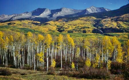
|
|
advertisement |
|
|
advertisement |