| |
| |
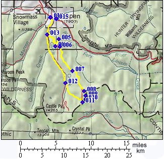
Richmond Hill Rd via
Taylor Pass s(u)
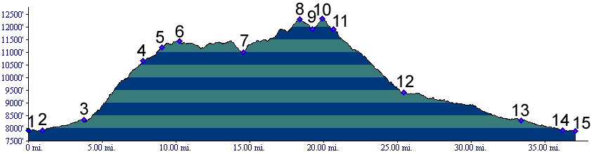
There are several possible summit
points on the ridge east of Taylor Pass, higher
than Taylor Pass itself. This double track across
a flank of Taylor Peak is the highest of the
double tracks. There is also a short out and back
to the top of the mountain itself. From there you
can enjoy a great view of the surrounding area and
Taylor Park
From North East: The Richmond Hill route leaves
the paved Castle Creek Valle Rd ( towards Taylor
Pass and others) about 3 miles up from Aspen. A
steep, well graded dirt road climbs up Richmond
Hill in tightly bound switchbacks. But this climb
is not an escape into the wilderness. At the top
the exhausted cyclist is greeted by a chairlift.
Another option would have been to ride ski area
trails to this point. Some people actually take
the bicycles on the lift to the top. Whatever mode
was used to get here, the ridge ahead is one of
the prime alpine ridge rides in the state.
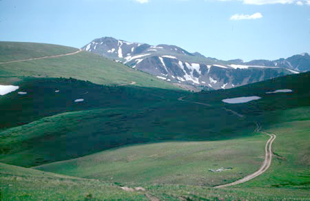
Intermittent rolling hills finally make their way
above treeline and open on a vista running along
the length of the Elk Mountains. From here on the road follows the western
boundary of the Collegiate Peaks wilderness.
Although most of the ride takes place on Richmond
Hill, the two highest elevation points are south
of there, first on an unnamed knoll between Gold
Hill and Ashcroft Mountain, and the highest point
along the route on a hill above Taylor Pass. From
there a short spur leads to a 12430ft high point
overlooking Taylor Park. Between the two high
points a single track trail leaves the ridge to
cut off the highest section of the route,
including Taylor Pass. With that option the other
summit point on Richmond Hill becomes the point of
highest elevation, and the route is covered on the
page Richmond
Hill summit(u).
Single Day. The Richmond Hill route makes
for a great dayride. The route consists of so much
climbing that just a few miles of spinning on flat
roads afterwards feel really good to unwind the
legs.
 |
 Approaches
|
|
advertisement |
|
|
advertisement |