| |
| |
Wolf Creek Pass
including out-and-back to FR39 Fall Creek Rd/Treasure Mtn(ow) Wolf Creek Pass goes through
the heart of the Eastern San Juan Mountains.
This Continental Divide crossing is a favorite X
country ski destination in late fall and early
summer, when the snow lingers long into the hot
days. Traditionally the area often gets the
state's largest snow fall amounts. In the winter
of 1978/79 over 70 feet of snow were logged.
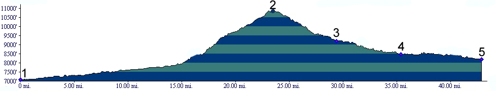
From South. A wide fast road with a good shoulder leads to the summit. About eight miles below the summit the road does two very large radius switchbacks. At the summit road signs warn of these "dangerous curves", which cyclists still can take without using brake pads. Still - these two curves and the vantage points they give on the scenery are the most distinctive part of this pass. There are good views of west fork of the San Juan River below. After that it's grinding climb on the wide shoulder of a broad highway with several waterfalls tempting the touring cyclist to admit that this is not a race and stop. From North From South Fork
there is no sign of the high mountains to the
south. Following the south fork of the Rio Grande,
the valley seems to deepen gradually. The first
part of this climb has no shoulder and traffic can
be dangerous during times of high traffic. This
changes when the road passes a trailhead on the
north side, several miles after the junction with
the Park Creek forest road. It is a mystery to me
why the shoulder happens to start at this point. The road now goes through a short
tunnel and then later a little longer gallery
tunnel. The slopes on the side of the road seem
gradual and subdued, considering this is the heart
of the Eastern San Juan Mountans. When the road
passes the ski area, you are almost at the top.
From the gentle wide summit and interesting foot
trail heads south, following the continental
divide. It climbs a small knoll of a mountain
above the ski area, which is a great vantage point
onto higher peaks to the south.
Three Day Road Tour. Wolf Creek Pass has been the finishing touch of many a Memorial Day weekend tour, organized in the distant past by the Denver Bicycle Touring Club and the Heartcycle Club. The first day of this tour begins in Alamosa and leads over La Manga and Cumbres Passes to Chama, New Mexico, once measuring 87 miles. The second day ends in Pagosa Springs, 79 miles. The last day constitutes a 90 mile return to Alamosa and includes this pass. Sometimes car shuttles have been used to shorten the first or last days. (m1:86.05.26). One Week (Very) Large Group Ride:
(<Red Mountain Pass|Yellowjacket
Pass>): The Denver Posts "Ride the
Rockies" crossed Wolf Creek Pass three times
between 86 and 05, during 91 96 and 02. The day's
stage was Pagosa Springs to Alamosa or reverse,
covering all of 89, 90 or 99 advertised miles,
depending on what year's tour description you
believe.
History Hayden Survey (<Elwood Pass|Hayden Pass>): In
1873 the nearby mining boom in Summitville was in
full swing. A subgroup of the Hayden Survey
examined this pass as part of the passes around
that area.
After main invented the car, he
needed a place to drive it. And so his interest
returned to Wolf Creek Pass. Modern road building
became a larger priority than in the days of the
quaint, but slow horse drawn carriage. So strong
was the desire for good roads that it became a
national priority. And where there is priority
there is money. In 1907 president Roosevelt backed
a plan to spend 25 percent of national forest
gross income on automobile roads through the
forests. Several pass roads were already
automobile fit before it became a national
priority, amongst them Ute Pass near Colorado
Springs and Old La Veta Pass. In 1913 the Colorado Highway
Comission received federal funds for its first
major project, and together with the forest
service started work Wolf Creek Pass. Wolf Creek
Pass received no noticeable use prior to 1913. Now
it became the frist designated automobile route
crossing the continental divide. It formed a
connecting link for automobile travel between the
Front Range and Durango, and was given the name
"The Spanish Trail". The entire route that was
being made travel fit was Walsenburg, La Veta
Pass, Fort Garland, Del Norte, Durango and onwards
to the newly created Mesa Verde National Park.
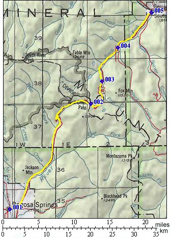
  Out and
back to Treasure Mountain area on FR39 Fall
Creek Rd Out and
back to Treasure Mountain area on FR39 Fall
Creek RdAn interesting gravel climb departs from US160 at roughly mid climb up on the west side. It's FR39 Fall Creek Road. A fairly good gravel road leads to a divide that opens up the view onto the main ridge of the Eastern San Juan Mountains. But rather than go back down to the East fork of the San Juan River, the road just contours along in endless meanders to approach Treasure Mountain. As expected the road's rockiness increases dramatically. Near the end there are several bifurcations onto different parts of Treasure Mountain. The highest branch reaches an elevation that is roughly the same as that of Wolf Creek Pass. The main branch of the roads continues with a very rough trail with an unmaintained appearance. I don't think I want to propel a bike over it.
Slideshow
of the FR39 Out-and-Back to Treasure
Mountain
Ride with this One Way point as highest summit (and no two way summits) PARTIALLY PAVED / UNPAVED ( < Brown's Pass | FR634 Pagosa Springs s(u) > ) FR648 West Fork Rd, not far
from the jct with US160 <> FR648 south
<> US160 north <> FR36 Fall Creek
Rd to its end, including all dead ends in the
upper area, with a bit of additional
exploration on foot: 28.6miles with 3820ft of
climbing in 4:14hrs (garmin etrex 32x
m6:24.09.15)
|
|||||||||||||||||||||||||||||||||||||||||||||||
 Approaches
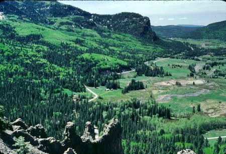 A
Dayride with this point as intermediate summit
is on page:
A
Dayride with this point as intermediate summit
is on page: 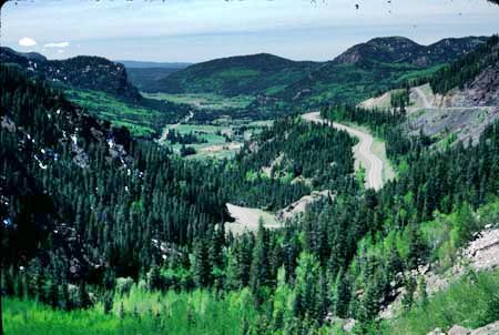 Modern Highways (
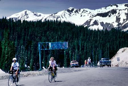

|
|
advertisement |
|
|
advertisement |