| |
| |
Red Mountain Pass
The San Juan Mountains are the
largest contiguous area above 10000 feet in the 48
lower states and Red Mountain Pass is the highest
paved pass through these mountains. The
"contiguous 10000 feet statistic" gives a good
idea about this landscape and this pass.
This is a plateau, as well as an alpine range.
It's a set of sculptured peaks set on top of a
table, set off by cliffs of varied steepness
draping over the plains below.
The summit of Red Mountain Pass is a pretty spot with good views in two directions. But despite its altitude, within half a mile north of the summit, the road follows the headwaters of the Uncompaghre River, and deep forest is never far away. - Instead the most spectacular country along the road is further down, along the Uncompaghre Canyon climbing up from Ouray. It was also the section, that was historically the most difficult to overcome. Above that, the leftovers from countless old mining structures, set between piles of red dirt, testify to the history of this route.
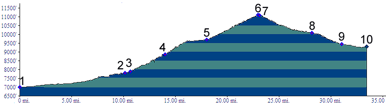
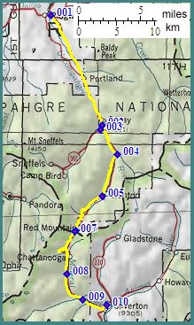
From North. The profile begins down in
Ridgway to show the maximum elevation gain. The
pass road starts in Ouray at point 2. The Red
Mountain Pass play starts with its main act. After
a few introductory switchbacks above Ouray follows
the traversal of Uncompaghre Canyon, using several
short shelf road constructions. These have as much
exposure to straight dropoffs immediately next to
a narrow shoulder, as one is ever going to see in
Colorado on a paved road. From South. (also described upwards) A
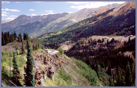
steady climb following Mineral Creek offers
glimpses up side valleys: ragged ridges reach
above the tops of forested slopes. Near
Chattanooga ( today, only a name on the map ) the
road reaches a large radius switchback curve, that
seems like a momentum gathering device, designed
to catapult the traveler to the top in slingshot
fashion. - If only it were that easy. Climbing
above the valley floor, the old mining debris
below slowly takes on a toylike appearance. At the
same time the full dimensions of a series of
cascades at the other end of the large radius
switchback becomes apparent. After that the
remainder of the climb is surprisingly straight.
History The story of Red Mountain Pass are snapshots in
time. Between the horse drawn wagon and the
internal combustion engine, conditions conspired
to get yet another mode of transportation through
the narrows of Uncompaghre Canyon: the railroad.
Sometimes it worked - sometimes it didn't. Hayden Survey(<Molas/ Coal
Bank Pass|Lizard
Head Pass>): Little has been added to the
maps produced by the Hayden Survey. During its
second year of exploration, 1874, the Hayden
Survey set its eyes on the San Juan Mountains and
Baker Park, as the Silverton area was known. A
major objective was to find a route into the
isolated mining settlement that was suitable for
heavy mining equipment. Several primitive routes lead into the mountain
fortress. All of them had their own peculiar set
of unsolvable difficulties. They had entered the
area from the east over Cinnamon Pass.
Another option, a trail following Animas canyon
from the south was considered impassable.
Also to the south, a trail existed following the
east side of Sultan Mountain, the general area of
today's Molas
Pass road. It too was considered useless for
mining equipment. Maybe the north had a better
access route ? Their progress up Mineral Creek to
Red Mountain Pass presented no problems. It was
descending the other side to the box Canyon above
Ouray, that geographer Rhoda concluded flatly :
"The canyon bars all egress". There was only one general direction they hadn't
tried yet, west. The route lead them to an unnamed
crossing above Trout Lake descending to Lizard Head Pass,
a stretch that would be better described as a
mountaineering route than a "suitable for heavy
mining equipment". And so Red Mountain Pass
alluded the Hayden Survey as a feasible connection
between Ouray and Silverton of the 1870s, although
the motivation to find a route, in terms of
potential profit for others, was high enough.
The Leadville Boom (<Cinnamon Pass|Stony Pass>) also
Otto Mears Passes (<Owl
Creek Pass|Hesperus
Pass>): It took until 1882 for
motivation to mount to the point of action. In
1882 construction began on a toll road over Red
Mountain Pass. The final impetus was provided in
the form of gold at the nearby Yankee Girl Mine.
The fact that both Silverton and Ouray were about
to have functioning rail heads, courtesy of the
Denver Rio Grande Railway, also made this project
more feasible.. Ouray grew and so did it's wealth. Insuring
that the thriving town had toll roads, on which
goods could flow in and out, was the business of
Otto Mears. To the west his earlier additions to
his toll road empire, going over Blue Mesa Summit
and Cerro Summit,
connected to other Mears roads further east. The
transportation situation to the south however
could stand some improvement. A very bad trail
still followed lower Uncompaghre Canyon. One fork
lead to Mineral Point, then followed a route east
of Red Mountain Pass, connecting with the Engineer Pass - Cinnamon Pass
Cutoff road between Lake City and Silverton.
The other fork connected with mines on both sides
of Red Mountain, and it was this fork that Otto
Mears elected as his next project in 1882. Called
the Rainbow Route, its most difficult part was the
section of the Uncompaghre box canyon,
Construction would cost 10000 dollars a mile, a
huge amount for that time. When the road reached the top, Red Mountain
Pass provided a connection between the color
exuding mines at its top and Ouray, rather than
Silverton, in spite of the fact that Silverton was
located on the easier side of the pass. The town
of Silverton begrudgingly corrected this situation
by hiring old Otto to build the missing connection
in 1884, and voila a Red Mountain Pass road. Otto
operated the toll road until 1891, the same year
that he completed a railroad that effectively
reduced the need for the toll road as through
road. Railroads(<Hagermann
Pass|Hesperus
Pass>). Old Otto also plays the leading
part in the next chapter about Red Mountain
Pass, the time when it was almost crossed by a
railroad - almost, but not quite. To explain
how much it would have meant to lay tracks down
that last remaining link between Ironton and
Ouray, we have to paint a picture around it. We last met the Denver Rio Grande railroad (DRG)
laying rails to Aspen to thwart competition from
the Colorado Midland railroad across Hagerman Pass.
Meanwhile the DRG had extended its Aspen service
through Glenwood Canyon to Grand Junction,
converting it to standard gauge in the process. As
already mentioned above, a spur from the new
mainline also reached into Ouray. On the other
side of the mountains the DRG San Juan branch in
the San Luis Valley had grown too, reaching all
the way up into the isolation of Silverton through
the previously considered useless Animas Canyon
route. The isolation of Baker Park was relegated
to history with one set of iron rails that reached
this el Dorado even before Ouray was connected to
rails on the other end. Railroad topology was
starting to resemble connected loops. The
remaining tentacles reaching up valleys were
getting less and less common. But one critical
part of a loop was still missing, the connection
between Ouray and Silverton. Traveling from Ouray
to Silverton on rails still required a detour
through Antonito, Alamosa, Buena Vista and Grand
Junction, just to mention a few stops. The
distance by wagon road between the two stations
over the pass was 26 miles. The idea that these 26 miles needed to be
connected by rails was hatched by toll road
operator Otto Mears, whose stature had grown far
above toll road owner at this point. He was now in
his 50s and slowly started selling his empire. 170
miles of toll road were still under his control,
and 26 of them just happened to go over Red
Mountain Pass, the missing link between Silverton
and Ouray. Otto no longer had the ambition to
build an industrial railroad empire. Instead he
was at the point of selling whatever empire was
left. But the rails between Silverton and Ouray
became his fixation, a point to prove - just to
show that it could be done. He named his dream the Silverton Railroad, and
during the summer of 1888 he successfully laid
rails from Silverton over Red Mountain Pass at a
spot a hundred feet above today's road. Unlike the
toll road he had built earlier, this time he began
building from the easier side of the pass. He
called his crossing Sheridan Pass. The problem he
faced after that was the same problem that the
Hayden Survey under Franklin Rhoda faced 14 years
earlier, how to get down Uncompaghre Canyon - only
this time it was with a train instead of a survey
party. Looking back from Ironton at the time, we
would already see switchbacks zig zaging between
tailing piles, and turntables busy shunting trains
to mines at Vanderbilt, Yankee Girl, Corkscrew
Gulch and Joker Tunnel. Otto considered an
electric or a cog railway to cross the gulch
ahead. But costs were too high for such a low
population density. The line serviced mines from
Silverton, but remained stuck on the precipe above
Ouray. A distance of 8 miles with a 17 percent
grade remained without rails. To take the train to
the other side still required a detour through
Antonito, Alamosa, Buena Vista, Aspen, Grand
Junction, Ridgway and Ouray ( just to once again
name a few stops along the way). The failure irked Otto Mears. In his mind
Silverton and Ouray still needed a rail connection
that does not require a detour through Buena Vista
and Grand Junction. If not over Red Mountain Pass,
then perhaps the round about way over Lizard Head Pass
Pass was feasible ? His next attempt would
be longer than the Red Mountain Pass route, but
still considerably shorter than the Grand Junction
- Buena Vista option. Lizard Head Pass was the
biggest obstacle on this route, but not the first
one. The story continues with a minor often
neglected crossing near Durango, Hesperus Pass. Even though Otto Mear's Silverton railroad over
Red Mountain Pass was a financial failure it was a
success in other terms. Those 16 miles of railroad
proved to be by far the most fabled, irresponsibly
quaint, written about miles in Colorado railroad
history. What other rail journey had a sleeper car
on a two hour run covering 16 miles ? Modern Highways (<Rabbit Ears Pass|Molas Pass/ Coal Bank Pass>): Enter the automobile. Red Mountain Pass became the first section of the "Million Dollar Highway" Route, a name that still is used in tourist brochures today. The name dates back to the time between the wars, 1921, when names like the "Victory Highway", "the Triangle Route" and the "Old Trails Road" were part of the vocabulary. The Million Dollar Highway route also included Molas Divide/ Coalbank Pass. In the following three years highway work resulted in a one way gravel road with turnouts, a significant improvement over what was before. By 1939 the road was kept open during the winter. Today's road is located above the old Mears Toll road. Cycling - Ride the Rockies: (<Molas
Divide/ Coal Bank Pass|Wolf Creek Pass>):
The Denver Posts "Ride the Rockies" cyclists
have crossed Red Mountain Pass only three times
between 86 and 05.
|
||||||||||||||||||||||||||||||||||||||||||||||
 Approaches
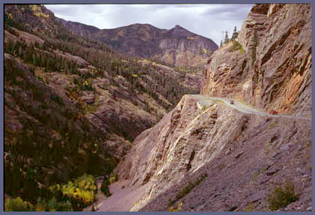
|
|
advertisement |
|
|
advertisement |