| |
| |
Lizard Head Pass
A steep spire graces the top
of a rounded 13000 foot mountain like the horn on
the head of a unicorn. The picture has evoked the
image of a lizard head in early travelers, and
this pass acquired its name. Still, the best view
of Lizard Head Peak, that I know of, is from Blackhawk Pass. As
seen from the Lizard Head Pass road, the rock
looks more like a monument standing in isolation,
something fit for a southwestern canyon, and
somehow isolated from its alpine environment.
Other high alpine mountains are visible during a
bike tour over the pass. Flanks of three 14
thousand foot peaks, El Diente, Mount Wilson and
Wilson Peak can be glimpsed from far below, when a
gap in the deep green canyoned foreground appears,
to let the snow covered heights shine through.
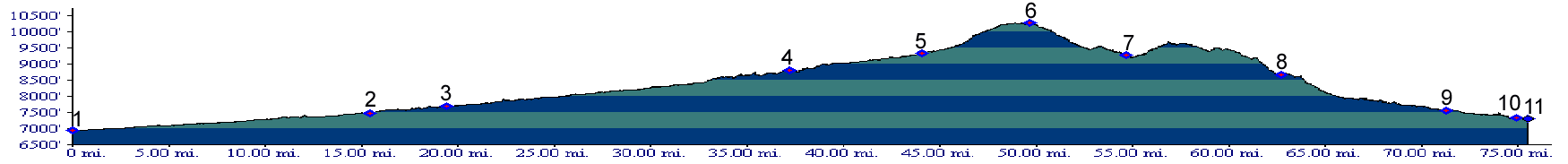
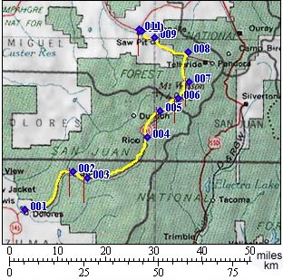
The Lizard Head Pass - Dallas Divide route is one of two modern asphalt ribbons laid across the San Juan Mountains in a north southerly direction. The other one is the more centrally located Molas Pass/ Coal Bank Summit - Red Mountain Pass route. The route over Lizard Head Pass was more important in the very early history, but then was eclipsed by economic factors. When two railheads reached to both bottoms of Red Mountain Pass, it became the focus of road building activity. Lizard Head Pass is also the western most paved pass in the San Juans. The summit that would intuitively occupy that position, the Dallas Divide, reaches within one mile "westerliness". In spite of this, the view to the west of Lizard Head Pass is not of a landscape falling off onto a plain, but of more mountains.
From North. The first stretch of road, between Co62 connecting to the Dallas Divide, and Telluride can be unpleasant to ride during times when the rich commute to their weekend properties in Telluride en masse. At the turnoff to Telluride stands a new super sized gas station, doing all it can to dispel the idea of picturesqueness, and charging record prices for both milk and gasoline. Past the Telluride turnoff Co145 climbs a slanted plateau above the South Fork of the San Miguel River, affording good views of Sunshine Mountain. The climb surprises through its relatively shallow grade, even some extended downhills. The major peaks visible from here are set behind the steep canyon, carved by the South Fork of the San Miguel. The road makes a hook to the east to cover Ophir Loop, the site of Otto Mears adventurous railroad trestle construction. Once the road passes mountain ringed Trout Lake and its surrounding peaks the summit is only 2 and a half miles away. From South. (also described upwards) The
ride from Stoner following the Dolores River is a
very long climb with a barely noticeable, gradual
climb. The route follows the forested canyon of
the Dolores River as steady as you can. This is a
more sedate ride without the scenic drama of
Telluride's box canyon or the high peaks of the
summit. Even when the grade finally picks up, past
the Dunton turnoff, the most talked about view in
a group ride is that of the needle like rock
piercing skyward. The surrounding high ranges
hidden mostly from view. The summit is a broad
alpine meadow, a rugged wall rising to the east,
which is especially stone curtain like during very
late light. The area is often used as primitive
camp site. 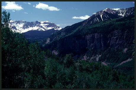
A Day on a 15 Day Tour: (<Dallas Divide|Hesperus Pass>) A Dayride with this point as intermediate
summit is on page: Lone Cone Pass History The nearby Dallas Divide was part of the well
traveled Old Spanish Trail. Early Spanish
explorers traveled it, and ta trail crossed the
pass by the mid 1830s. Hayden Survey (<Red Mountain Pass|Stony Pass>): In 1874 the area of prime mapping concern for the Hayden Survey was not the top of Lizard Head Pass, but rather access routes to an area showing signs of great mineral wealth, Baker's Park or today's Silverton area to the east. The survey had explored potential roads out of the isolated mountain valley in all directions, including today's general routes over Molas/ Coal Bank passes, Cinnamon Pass and Red Mountain Pass. None of them showed potential for a road that could carry heavy mining equipment. In the next futile attempt we see them ascending
the south fork of Vermilion Creek, then scrambling
over something they named Bear Creek Pass, only to
arrive above Trout Lake, near the top of Lizard
Head Pass. This was a mountaineering route, and
definitely unsuitable for heavy mining equipment.
They mapped the area, then climbed Wilson Peak and
Mount Sneffels. They scrambled back over the same
difficult route to Silverton. Their search
for a road suitable for heavy equipment continued
from Silverton to Stony
Pass. In spite of the fact that the Hayden Survey's
priorities, guided by economic realities of the
time, were centered further east, a wagon road
crossed Lizard Head Pass before the other San Juan
north south axis, the Red Mountain Pass route was
improved into a reliable toll road by Otto Mears.
A wagon road existed over Lizard Head Pass already
by the 1870s. But when railheads reached both
sides of Red Mountain Pass in Ouray and Silverton
it became the principal axis of ore removal from
the San Juans. 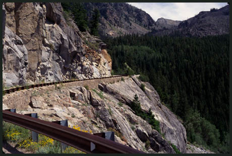 Railroads(<Dallas
Divide|Rollins
Pass>): If not Red Mountain Pass,
then Lizard Head Pass. This was Otto's motto. An
attempt to lay rail over Red Mountain Pass in
order to provide a missing link between Denver Rio
Grande tracks in Ridgway and Durango was left
dangling on a cliff over Red Mountain Pass. But
Otto Mears would not let his dreams of a railroad
through the San Juan Mountains slip away so
easily. The Rio Grand Southern railway began building at
both ends. Starting at existing DRG tracks in
Durango the southern division crossed Hesperus
Pass. After crossing the Dallas Divide from
Ridgway, the northern division turned up the San
Miguel river, servicing mines wherever profitable,
Placerville by the fall of 1890, followed by a
spur to the Pandora mine near Columbia. - Columbia
? you say. Later Columbia was deplored by the
postal service to change its name because of a
bewildering preponderance of that name. Telluride
seemed an appropriate name for a town where silver
had just been found inside this mineral, and
Telluride it became. After completing the profitable spur to
Telluride, the real challenge of the entire
venture was now ahead, the final leg over Lizard
Head Pass. To the cyclist who has crossed Red
Mountain Pass and Lizard Head Pass the problems
faced by track construction here may actually seem
more difficult than over Red Mountain Pass. Both
passes must overcome a box like canyon where the
plateau characteristics of the San Juans become
apparent. On Lizard Head Pass this happens near
Ophir. Otto's answer was the Ophir Loop, a curved
trestle switchback connecting two mountain shelfs,
located above the turnoff to Ophir Pass. This time
the effort was successful and rails crossed the
gentle top between peeks ramping skywards in mid
1891. More trestles were required to descend the
other side, where rails crossed the Dolores river
about halfways between Ophir and Rico, labeled
these days as the Galagher trestles. Lizard Head
Pass was Mears' final pass building triumph. It
seems fitting that he used a view of the needle
like peak for which the pass is named, when
publicizing the rail journey. The magnanimous detour was finally complete when
the celebratory last spike was driven between the
spurs from both ends near Stoner. Rail
through the San Juans at last! After three years
of work Otto Mears had his missing rail link in
December 1891, all 217 miles of it. The distance
over the wagon road between Silverton and Ouray,
also belonging to him, was only 26 miles. To
celebrate the event Mears hired the famous Hayden
expedition photographer Jackson to ride along on
the first journey and stop the train wherever
inspiration struck. There was no shortage of
narrow gauge rolling stock for the railroad. The
DRG had converted to regular gauge. But discarded
DRG narrow gauge stock continued to steam on the
Rio Grande Southern. After this remarkable effort this comes as a
shock. But it only took two years for this
"futile, transcendently triumphant" railroad to go
bankrupt. It wasn't really Otto's fault. He had
already proved his keen business sense by building
an empire of toll roads stretching across
Colorado. In 1893 president Cleveland repealed the
Sherman Silver Purchase Act, legislation that had
in effect subsidized silver production and kept
the mines operating at the expense of the
taxpayer. The resulting panic put an end to the
boom heard in Leadville many years earlier. But
this thread is about the railroad, and it
survived. The DRG took receivership and steamed on.
Especially hard times struck during the great
depression, when another whimsical invention
ingrained images of strange and weird rail travel
into the minds of thousands, if not millions. The vehicle dubbed the Galloping Goose begins in
front with the sporty body of a Pierce Arrow Motor
car. Without transition it metamorphoses to a full
blown school bus, only to have a truck bed
attached to its rear. The whole thing teeters on
narrow gauge bogies that make the whole
contrapture look like it's about to tip over. The
image of a galloping goose, prominently displayed
on the door of the school bus portion completes
the unique picture. To me personally, the goose
looks like it is sprinting. But who am I to say
weather a goose gallops or sprints, when they are
not really known for either. Galloping Goose is
the official name for the vehicle. Trains were
still running over Lizard Head Pass in 1952. But
just a year later, even the steel rails were gone. The images of the Otto Mears railroads remain.
The Denver Rio Grande Southern, but especially
Silverton Railroad are favorites with railroad
modelers. This railroad is the undisputed
quaintest, most charming, irresponsible and
unpredictable railroad around. A scene modeled
after the Silverton provokes suspicion of an
overactive imagination, when instead it was
inspired by a historical photograph. Cycling - Ride the Rockies: (<Grand Mesa summit(u)|North La Veta Pass>): Between 1986 and 2005 Lizard Head Pass was twice on the Denver Post's "Ride the Rockies" itinerary. It is difficult to include the many great San Juan passes very often in a route that is usually anchored in Denver. But it happened in 99 and 03. The stage was Cortez to Telluride. |
 Approaches
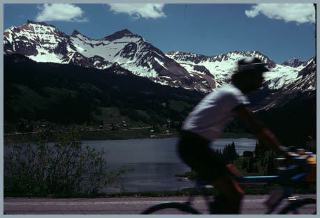
|
|
advertisement |
|
|
advertisement |