| |
| |
Ebbetts Pass
This pass through the Sierra
Nevada Mtns is nothing like its neighbor to the
north, Carson Pass
- and that is a good thing. Ebbetts Pass is pretty
much perfect for cycling, even though it doesn't
even have a shoulder. And that can only mean one
thing. Traffic is so light that it doesn't need a
shoulder. All these curves, dips, switchbacks,
humps and swerves would slow any traffic down to
bicycling speed anyway. It's hard to believe that
this route was once suggested as a railroad pass.
Today there is a wide selection of gentle wide
routes through the Sierra Nevada Mountains that
seem perfect for a railroad, but this is
definitely not one of them
From West. Ca89 reaches a low point
point, where it crosses Markleeville Creek,
immediately south of town. Following the east fork
of the Carson river, one can see the fishermen at
work at the numerous turnouts, while climbing
gently. At one point a glimpse of a high peak
actually shows the area, where this road is
heading. At the jct with the road up Monitor Pass
a sign warns of a 24 percent grade ahead. Actually
the steepest parts of the road are on the next
summit after Ebbetts Pass: Pacific
Grade Summit The dense forest provides relief from the intense
summer heat. Then several switchbacks open up
views on the drainage below and its varied rock
layers, including some soft shales, that also give
this landscape also a dry look, in spite of the
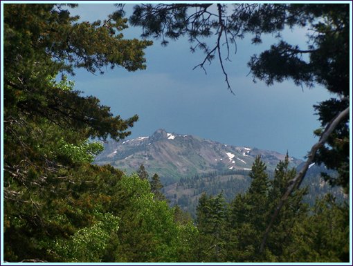
lush vegetation. A few steep squiggles in the road squeeze the
pavement next to a rock wall. A dome shaped
mountain comes into view straight ahead, lined
with turrets along the ridge line to the north,
much like roof gables on medieval buildings. The
road climbs for a while in this rocky landscape,
but the summit is in the trees. The Pacific Crest
Trail crosses a short distance before the summit
of Ebbetts Pass. Here the trailhead parking lot is
a small dirt lot, very different than the shopping
center style parking lot at the trailhead on Carson Pass. 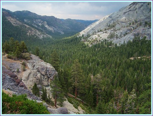
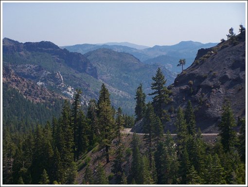 From East. (described downwards) A short
descent leads into Hermit Valley. The road
traverses along the forested ridge. The view ahead
shows more bread loaf shaped mountains. There is a
free campground without water in Hermit Valley and
one or two signs that state in a sentence or two,
that somebody live here once before.
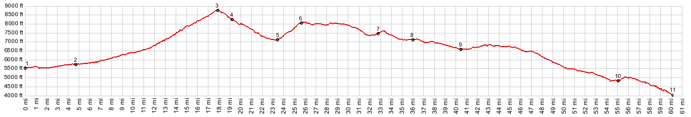
Dayride COMPLETELY PAVED: Ebbetts Pass x2 , Pacific Grade Summit x2 : jct Ca4 - Ca89 <> Ca4 <> Ebbetts Pass <> Hermit's Valley <> Pacific Grade Summit <> turnnaround point at Lake Alpine Camgground: 56.7miles with 6490ft of climbing in 5:21hrs (VDO MC1.0 r2:13.7.1) Notes: a hot and slow ride, but not as hot as in "Saekruh-Mennow". There it was 104 degrees, 129 in Death Valley on this day History The Fur Trade: In the 1820s fur trappers
were the first anglo Americans to explore the
northern Rocky Mountains. Today many of their
names can be found on historical roadside markers,
probably none more often than Jedidiah Smith. But
his explorations reached further west than the
Rocky Mountains. Apparently, in an effort to find new hunting
grounds, Smiths party followed the Colorado River
up its source, and eventually crossed the Mojave
dessert into what was Mexican territory at the
time. Over the next months Smith's party traveled
to the San Gabriel Mission, and then was detained
by the governor of Mexico. But after finally being
able to leave, they explored the San Joaqium
Valley and accumulated 1500 pounds of beaver fur. The easiest route back east to Salt Lake and the
next Rendez-Vous would have been further north,
which would also become a route of the Oregon
Trail. But Smith did not know about this, and so
they ended up crossing the Sierra Nevada Mountains
at Ebbetts Pass. Jedediah Smith would make another arduous journey
to California. During that trip he managed to also
travel north to the Columbia River and return
further north. Railroads: The head of
an exploration Company with the curious name
"Knickerbocker Exploration Company" also thought
for a short time that this would make a good
crossing for the planned transcontinental
railroad. Only a year passed, when he returned to
the pass and found the territory to be unsuitable.
Still, maybe because his name was attached to the
pass by the Geological Survey in 1893, this is
fact that is on all the roadside markers.
the Goldrush: After California had become the center of the Goldrush starting in 1849, silver was found on the east side of Ebbetts Pass. A local road was built over the pass to connect with the town of Murphys, west of the range. Modern Roads: It was not until later, that Ebbetts Pass would become an option while travelling across the continent. But the main source of traffic always came and returned to more westerly parts of California. It was the main supply route between mines in Nevada and supplies in California. In 1926 Ebbetts Pass became part of the State Highway System and the first pavement appeared in the 1930s. Portions of today's roadbed are the result of realignment in the 1960s. Luckily there are still plenty of interesting curves and slopes left. Cycling: Today Ebbetts Pass is on many organized rides, amongst them the Ebbetts Pass Century and the Death Ride.
|
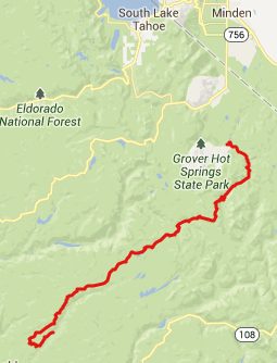 Approaches
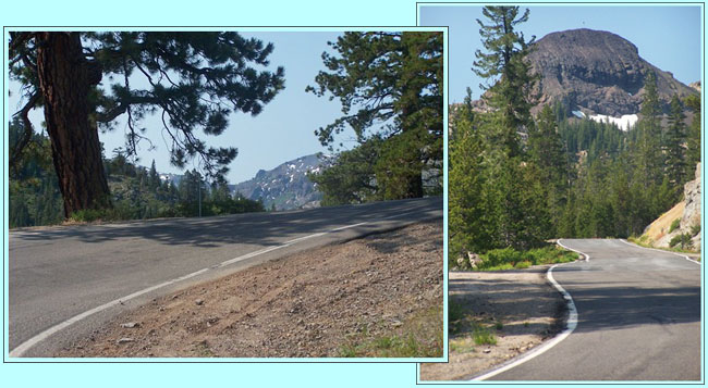
|
|
advertisement |
|
|
advertisement |