| |
| |
A347 Alcolea(sh)
This is a shoulder point on the road
that connects the Mediterranean coast in Adra with
the Alpujarras (foothill villages of the Sierra
Nevada). After this shoulder point, A347 continues
directly over the only paved pass across the
Sierra Nevada, the Puerto de la Ragua, (not
counting the Puerto de Santillana, which crosses
the eastern end of the range). This A347 shoulder
summit point itself is of practically no interest.
But the northern approach over AI6400 is, what
makes this bike ride. This is one of those curvy
roads that keeps cars away and it goes through a
couple of interesting Alpujarra villages: Darrical
and Lucainena.
Instead of turning towards Berja - the town in
the middle of all that cellophane, the route turns
left onto A461 and crests at a solitary tree,
picturesquely placed in between giant bare hills.
On the other side a 100m descend goes to the
reservoir: Embalse de Beninar. I am not treating
this last point as a summit point, because there
is no way to make this side at least 500ft high.
From a junction at the south side of the reservoir
both forks start to climb again, the other one to
Turon, and this route continues north through the
best part of the route: the old church of Darrical
lies below the road in the opening of a rugged
canyon. Just a little later comes Lucainena,
and this time the road goes right through it. From
here on nothing separates the viewer from the
Sierra Nevada except a lot of air. The route
merges onto the busierA347, which is the logical
thing for people to drive a car on, if they want
to get up here. Turning right the profile quickly
reaches a non descript summit point, with a far
view onto the Sierra Nevada 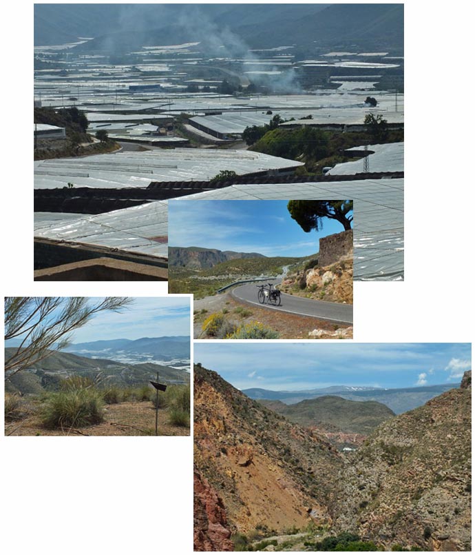 From East. A fast
descend leads to the edge of Berja. Along the way
the newer road bed parallels an old version of the
road, wich still has a bikable surface. But a
mountain bike would be better. The old stone arch
bridges and road house ruins are now a reminder of
a quaint older time. Soon the cellophane of Berja
comes into view, stretched out between gigantic
landforms. There is an Aldi supermarket above
Berja. My own route turned back towards the Rio
Adra. But I continued the profile on A347 to
maximize the elevation gain on this side, to the
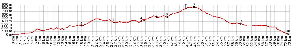
point where those two routes merge. Dayride with this point as highest summit: COMPLETELY PAVED: A347 Alcolea(sh) , additional out and back:
AI6300 6km north of Adra > A1175 north >
Embalse de Beninar > Darrical > Lucainena
>A347 south > A347 Alcolea(sh) <>
partial out and back to Hirmes > Berja >
back to starting point on AI6300, 6km north of
Adra: 45.2miles with 5570ft of climbing in 4:23hrs
(basecamp figures from Garmin etrex30 track:
r5:16.5.27).
|
|
|
advertisement |
|
|
advertisement |