| |
| |
Strada dell'Assietta s(u)
This is one of the great unpaved
ridge rides of the Central Alps. There is no snow
removal on this road, so the road opens, when the
last snowdrift melts, that you can't carry a bike
over. The road is unpaved but smooth on the north
side. The biggest obstacle for me was that one
last, steep angle snowfield, and a few muddy
stretches on the south side.
The road finally turns northwards, and it is clear that a wide gap in the enormous green ridge is the first goal. So now we are on the Colle d'Assietta. A host of directional signs are covered with more "personal signs", including stickers from all over the world, like a "Harry and Beth ride around the world" sticker, and a Stuttgart21 sticker. It seems this is the place to be, if you are a decal afficionado. You can turn right here, direction Forte Gran Serin, and also back to Col de Finestre. I'm told that this road ends soon. But on good weather days you can definitely walk along the ridge line on trails, that connect to the top of Colle delle Finestre. I have been told by my host that this is not a bikable route. Continuing on the Assietta Road towards the left,
there is a temptation to think, that now you have
most of the climbing behind you, at least that was
what I thought. Actually - in a way - this is
where it really starts. The ridge road starts with
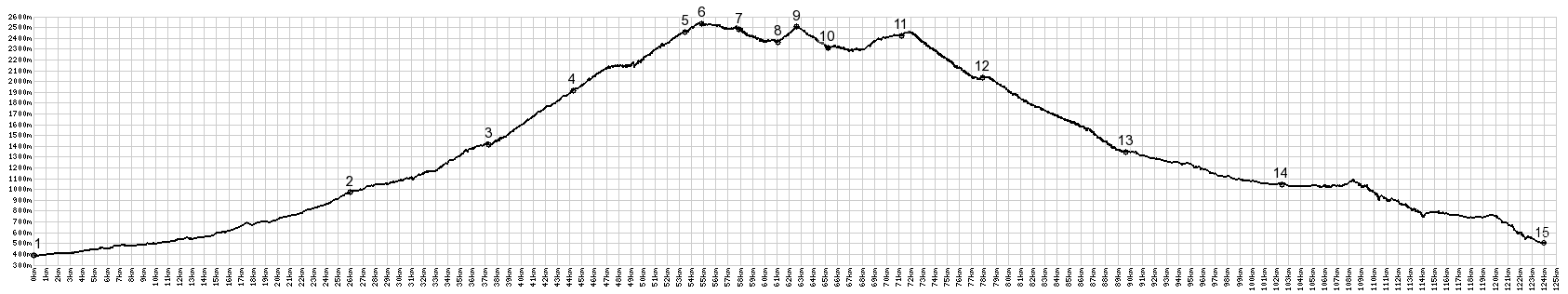
its numerous ups and downs. But the highest point
is quickly reached from here. It is located where
the road again encounters the enormous viewshed on
the north side. Nearby is a monument of a flying
bird - very fitting, though I don't see any real
ones up here. The bronze bird has been up here
since 1878, that's getting close to a century and
a half, thanks to the Club Alpino Italiano. From South. (described
downwards). That is the highest point, but only by
a few meters - and if snow and mud should be a
problem, it is still ahead. Looking ahead from the
summit, a road can be seen zig zagging up the next
trapezoidal green mountain block ahead. It appears
like it could easily be a higher than the summit,
but my altimeter said that it was not. Getting
there involves a few snowy parts on my ride, and
finally one large drift across the road, where it
traverses a steep hillside. This causes me to
carry my bike down around a small detour, lower on
the ridge, taking about 10 minutes. It is also the
reason for all the motorcyclists to turn around
here, if the previous sections didn't have that
effect yet. But they do not have to go down the
same way they came. There is also an option to
descend into the Susa Valley directly on a rougher
track. Soon the road reaches the top of a plateau, that
feels like the summit, but (as already mentioned)
is a few feet lower. Between here and the descent
into Montgenevre are numerous passes, all located
on low points of the road. They are labeled on the
elevation profile. Seeing Sestriere on the left,
really not that far down from the ridge, makes me
feel hopeful I would get back before dark, but the
road detours far to the the west of this town
before turning back. The road has lost elevation from the green loaf
and is now traversing in trees, apparently
searching for a gap back to the north side. it is
also much wetter here. Ski areas tend to be in
areas of high precipitation, and ski lifts are
threading up towards me from both sides. the. But
the track has not indication of going down yet.
Instead it continues to contour along the ridge.
Finally it reaches a T junction with a building,
you would like to believe is an old fort. After
all, that's the reason the road was built in the
first place. There are several fortifications on
the ridge. But actually this building looks more
like a ski industry utility of some sort. A this
point the climbing is finally over. The way down
to Col
Montgenevre, located in the center of the
ski town, happens with the low sun lighting up the
surrounding mountains to perfection. The water
tower architecture hotels look distinctive from up
here, maybe like a Fiat Cabriolet, if there is
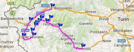
such a thing. 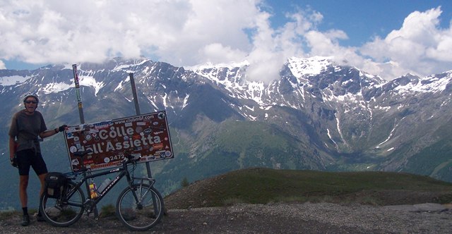 Dayride with this point as highest summit: Strada dell'Assietta s(u) , Colle delle
Finestre : Susa > Mena di Susa >
Colle delle Finestre > up Strada dell'Assietta
> Col de Assietta(shp) > Col Lauson(shp)
> Col Bigier(shp) > Colle Coste Piana(shp)
> Col Montgenevre(shp) > Cesana > Ouix
> back to starting point in Susa: 66.5miles
with 9349ft of climbing in 8;37hrs (Garmin etrex30
m4:14.6.19) The last day over a pass with different start
and end points was: Passo de Gavia Historical Notes: The history of this high, bare ridge
is tied up in a distant way with the history of
the world wars. in the 18th century it was the
habbit of the Hapsburg clan (or more respectfully
called "dynasty") to pass on the rule of a large
part of Europe to male descendents in the family.
But after Kaiser Karl the 6th there was no male
descendent, and so he passed the rule to his
daughter Maria Theresa. An 8 year long war was the
result (1740-1748). This is known as the Austrian
inheritance war, (Oesterreichischer
Erbfolgekrieg). School children to this day have to
learn the complicated shifting allegiances of that
time. For here I'll just mention the two
confronting powers, that had resulted for a battle
on this ridge in 1747, nearing the end of the war.
On one side there was the kingdom of Sardinia,
allied with Maria Theresa's Austro-Hungarian
empire. On the other side, the French had tried to
invade with little success further south. Now they
invaded by crossing Col
Mont Cenis and the fortification in Exilles,
and then tried to cross Col de Fenestre
to reach the town Fenestrelle in the south side of
the pass. Austria/Sardinia built up the Colle
d'Assiette with 13 battalions (each battalion
contained between 300 and 1200 men). In the end
4000 French soldiers died, 600 were captured. the
Saridinian kingdom retained the Colle d'Assietta
and lost 400 lives. At the next peace conference
in Aachen, Sardinia grew by adding areas around
the Lago Maggiore region. These conflicts, involving Hapsburg
descendants on one side, eventually reached their
first climax during WW1, when Austria-Hungary was
keen to start a war with Serbia. There are only few signs left from
this 18th century conflict. The forts standing on
the ridge now are from later fortification
efforts: The Forte Gran Serin near the top of the
road is from the 19th century. The fort on the
Colle delle Finestre (which I traversed on my
dayride, but is not part of the direct elevation
profile), also dates from a later time. During the
18th century this was fortified battery position.
|
|
|
advertisement |
|
|
advertisement |