| |
| |
Passo Bordala
From Ronzo an unusually wide, but curvy road
quickly climbs the gap above the village. It seems
every sign and billboard here has something to do
with percorso MTB, hanggliding or some form of
human racing. The top is in open forest with an
albergo. On the right, there is a turnoff onto a
narrow but busy road, that goes to a refugio.
From East. I think
that this side is more interesting. The road
becomes narrower and pulls off a few picturesque
tight turns below a crest of limestone. Rolling
down in long traverses, two separate villages
spread out around their respective church towers.
In the distance a sharp dagger like peak is barely
visible through the moist summer athmosphere. But
it is really only after the descent, from the
bottom, that all the features of this approach can
be seen in one view, the limestone crest on top,
the two villages foreshortened into a flat canvas
on green grape plantations - and this way it looks
the most impressive. On the bottom waits the supersmooth bike path
mentioned in the introduction. It is totally
separate from the road and follows the Etsch/
Adige river in both directions. Another separate
path connects to Lago di Garda via the ultra low
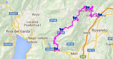
Passo Giovanni. History - Cycling: In 2002 this pass was part of the Giro d'Italia, leading from Bolognana over Passo Santa Barbara onwards to Passo Bordala. Dayride with this point as highest
summit: COMPLETELY PAVED: Passo Bordala , Passo Santa
Barbara , Passo Giovanni, additonal out
and back: Torbole, Lago di Garda > pista
ciclabile to Arco > Passo Santa Barbara >
Ronzo > Passo Bordala > Rovereto <>
out and back on Pista Ciclabile north to turn
around point just before reaching Trento >>
Pista Ciclabile south > Mori > Loppio >
Passo Giovanni(shp) > Nago > back to
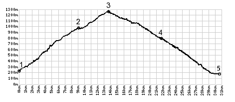
starting point in Torbole: 66.3miles with 5308ft
of climbing in 6:30hrs (Garmin etrex30 14.6.2) The last day with different start and end points
is on page: Passo
Lagostrello
|
|
|
advertisement |
|
|
advertisement |