| |
| |
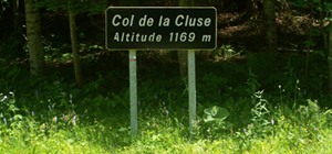
Col De La Cluse
I didn't find this small remote
road, winding its way around limestone cliffs
and over high meadows in the northern end of the
Chartreuse until my last ride in the area.
That's a a shame. There would have been more
small roads to explore here, expecially the
gorge between Col de la Cluse and Col des Egaux.
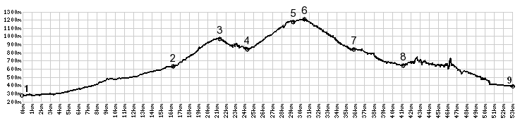
This short road goes over two passes. This is
the higher of the two.
Looking back various triangular limenstone cliffs
on edge, they have the shape of ship hulls at an
angle before descending into the depths. I would
name one of these mountains Lusitania. These
wedges tower over a deep valley in the center of
the Chartreuse range. Looking forward the goal
seems obvious: a moderately shallow gap where two
straight lines running down from forested
mountains meet. The pass is a peaceful meadow with
a sign between wild flowers. But the road keeps
climbing a little more past the pass. It reaches
its highest altitude a little later a le Desert
d'Entremont, a very small and peaceful ski area -
yes, I think there is such a thing. During a
Sunday in July the place was busy with people
walking the meadows. This is a great vantage point
onto the cliffs of the southern Chartreuse. From North. (described
downwards). After a few picturesque turns
celebrating the green mountain meadows the road
disapears in the forest and steeply descends to
Entremont le Vieux. Once in a while a view opens
onto the village. From here one can start climbing
the next pass Col du
Granier. But the profilel descends to St
Piere d'Entremont and turns back east towards Les
Echelles. The profile ends where it meets the
southern approach.
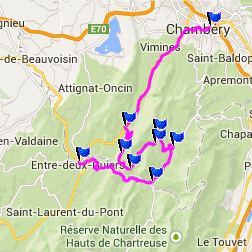
Col de la Cluse , Col du Granier ,
Col des Egaux :
la Ravoire > Chanbery > Col de Couz(shp)
> Col des Egaux > Corbel > Col de la
Cluse > Entremont le Vieux > Col du Granier
> down D285A > la Palud > various small
paved backroads back to la Ravoir with shopping
detour: 41.6miles with 4500ft of climbing in
4:05hrs (VDO MC1.0 m4:14.7.5) The last day with different start and end points over a pass on this tour is on page: D207 Aiguebelle - St Pierre de Belleville(s)
|
 Dayride with this point as
highest summit:
Dayride with this point as
highest summit:|
|
advertisement |
|
|
advertisement |