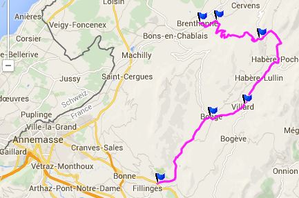
Col de Cou
Les Voirons is a small forested mountain
area east of Annemasse that has a
copious amount of small passes and other
summits to be crossed by the
appreciative cyclists of Geneva and
Annemasse. Col de Cou is in the middle
of this range, right between Col de Saxel
and Col de Feu. Of the three Col de Cou
is the highest by a few meters.
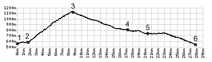 |
1.(550m,00.0km)
START-END NORTH: profile starts on
a small path. leaving D903
2.(590m,01.7km)jct:D35 - D235,
south of Fessy
3.(1116mm,08.6km)TOP: Col de Cou
4.(800m,017.0km)Villard
5.(750m,20.2km)START-END SOUTH:
Boege
6.(550m,27.6km)START-END SOUTH
ALT: bridge over La Menoge, north
of Filinges
|
 Approaches Approaches
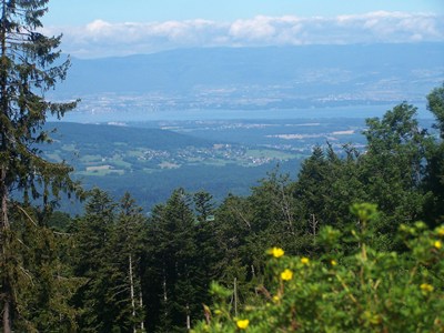
From North. There
are two separate approaches from the Lake
Geneva side that meet a short distance
below the summit. The profile follows the
smaller of the two roads , coming up from
the east. My ride was especially peaceful,
since the road was officially closed. But
I don't think this road sees a lot of
traffic even when it's open. The reason I
say this, is the presence of many gardens
immediately next to the road, even inside
one switchback. Would you want to plant
your radishes in the middle of traffic ?
Riding here, there are the usual subdued
views of Lake Geneva. Nearing the top is
an imaginative modern sculpture at the
sight of a WW2 resistance fight. The chaos
of war is hard to imagine now, in place
that is so peaceful. The top has a
extraordinarily expensive restaurant and
bar with a view, but only in the Lake
Geneva direction.
 From South. (described
downwards) A short descent leads into a
gentle green valley, aptly named Valle
Verde. There is no evidence here that
vertical walled alps are just a few kms
away. This landscape could also be in any
mostly flat country. After a short descent
you can also elect to climb back to Lake
Geneva via Col des Moises, or better yet
into a more scenically rugged area over Col d'Arces. From South. (described
downwards) A short descent leads into a
gentle green valley, aptly named Valle
Verde. There is no evidence here that
vertical walled alps are just a few kms
away. This landscape could also be in any
mostly flat country. After a short descent
you can also elect to climb back to Lake
Geneva via Col des Moises, or better yet
into a more scenically rugged area over Col d'Arces.
A Dayride with this point as
intermediate summit is on page: Col d'Ajon
|