| |
| |
Col d'Ajon
This summit with one paved and
one unpaved approach was the highpoint on a ramble
over several low passes in the Geneva area. A big
reason is the view of Mont Blanc
Now the road gets serious. It engages in 13
fairly seep switchbacks, mainly in the forest.
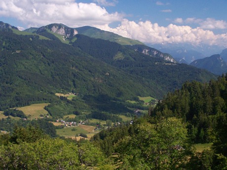
Slowly a gap ahead in the woods can be imagined.
The view now reaches obove the forested ridge
between here and Lake Geneva. In the collection of
a few houses marked Le Borbieu on the map a paved
road apears to crest a pass not far below. This is
enough to make anybody scratch his head and reach
for a map or zoom out the GPS. The road in
question is the upper wester approach to Col de
Plaine-Joux, and a short paved road reaching down
to it, illustrates that this is another possible
approach. On that option the pavement would be a
lot smoother than what is described here. The climb to Col d'Ajon now reaches above the
treeline and is accompanied by the clanging of
cows wearing monumental bells. The top is soon
reached. There is a parking lot and a building of
some sort. Unlike expected I did not see any
evidence of food and drink being served. The view to the south includes high alps,
including Mount Blanc, or at least the clouds
containing it, as if for safekeeping for special
moments. Nowhere on the top is there a sign
identifying this as a Col, but instead uses Ajon
as a placename 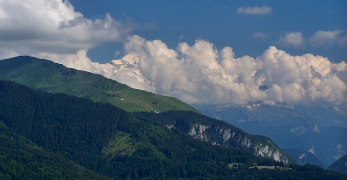 From South. (described
downwards) The road turns to rough dirt with rocks
immediately at the top. But a view of a few sharp
cornered peaks to the north make the couple of
switchbacks go by fast, and the surface improves.
Soon it is paved again but still very narrow. With
a few switchbacks the road hones in on Megevette
below, where a flower studded simple fountain
waits at the corner to D26. Now with more traffic
this wider road descends gently into Saint Jeoire.
There is a very short section of shelf road with
overhanging rocks with a Saint Mary Statue between
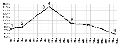
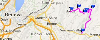
the traffic and the dropoff. Dayride with this point as highest summit: Col d'Ajon , C3 La Plagne
s[u) , Col des
Arces[1164m] , Col
de Cou[1116m] , D236 La
Houile(sh) , additional out and back: Annemasse
> Saint Cerques > Machilly > Col de Cou
<> out and back from turnaround point 300f
below Col de Cou <> top of Col des
Moises[1143m] > up Route des Arces > Col des
Arces > up C3 > C3 La Plagne s(u)[1180m]
> out and back to Tres les Mont > Col de
Feu[shp] > Lullin > D26 north > Bellevaux
> Col de Jambaz[shp] > D236 La Houile
(sh)[1100m] > D22 east > Col de
Teramont[shp] > up C5 Col d'Ajon > Megevette
> La Trappe > D26 east > back to starting
point in Annemasse : 73.3miles with7989ft of
climbing in 7:29hrs (Garmin etrex30 m4:14.7.15)
|
|
|
advertisement |
|
|
advertisement |