| |
| |
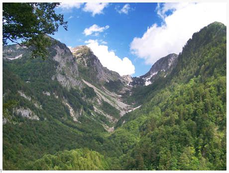
Dreznica - Kal Karitnica summit(u) This unnamed summit in the
Julian alps of Slovenia is a straight forward
steep climb on the south side, and then becomes
a tough portage reaching the actual summit and
down the north side. In spite of these
difficulties it has been written up as a
mountain biking route in other sources. During
my traversal of the route I met a group of 4
bikers from Suedtirol, who were following
printed directions. Had I not met them, I would
have turned back at the first summit because of
confusion about the route. The route starts in
the tourist town of Kobarid, which has a
natural, new excitement about it, that you can't
find in the more established resorts to the
west. Mountain bikers, paragliders an kayakers
seem to have found a new home here in the Julian
alps.
Approaches From South. From Kobarid you head out of
town direction Bovec. Then take a left, following
sings for Dreznica, immediately crossing a bridge
that serves as the first of many scenic
foregrounds for today's first objective. Roads
branch off on both sides upstream towards
campgrounds, and a nice road climb leads
downstream on the other side, to the Vrsno summit(u).
But for this summit you stay left towards the
impressive looking Krn peak. The paved road climbs
steeply and a second scenic foreground soon
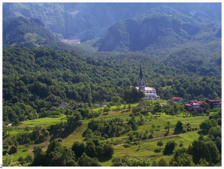
captures attention, the church in Dreznica. At the
junction in town a homemade painted illustrated
map serves to clarify the next part of the climb.
The general idea is pretty obvious. You climb an
unseen saddle between the peak Krn and the steep
somewhat lower ridge in front of it. A small paved
road traverses over to Drezniske Ravne. However
before entering towns, a also paved path branches
off to the right. Missing this turnoff is almost
inevitable. But little time is lost, because the
alternative soon soon ends, after passing the
three or four buildings of Drezniske Ravne, then
climbing a little ways towards a garden house of
sorts. Continuing on the right path the road swichtbacks
a couple of times to a parking lot. From here the
route continues as a narrow concrete path.
Innumerable switches continue, or at least it
seems that way, the road surface changing to rough
rock, except for the steepest parts where the
concrete surface returns. Even during
exceptionally good weather the steep slopes of Krn
often start to develop updraft clouds around it.
The saddle seems to draw closer as measured by how
high up on Krn we are. At one point it looks like
the saddle can't be far, but the path traverses
west and starts a new set of switchbacks. Finally
the road emerges on a high alpine meadow and
enters a farm type gate with a sign stating that
you are now entering a national park, also
enumerating all the things that are not allowed
there. Amongst these things is car washing,
cars and motor cycles. In spite of this all
of these (except for car washing) are common
encounters on the other side of the gate. During
the summer there are also cows up here, together
with the alm (cow herding) buildings that go along
with the support. After the long, high meadow the
road enters the forest again, still climbing
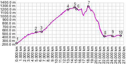
gently. Near what seems like the summit at 1259
meters, but is really only a first high point, are
remnants of WW1 fortifications, together with a
path that can be used to explore them. A short
informational tablet explains that the Italians
captured the peak Krn, and beat off the defending
Austro Hungarian empire. A dirt road branches off
to the left, climbing further and leading to more
WW1 fortifications. Maps do not show it continuing
far beyond that. At least one other detailed atlas
of the alps shows a small road descending from
this point to Cezsoca. In reality this road does
not exist. The three dirt roads branching off near
this point all dead end in the forest high up on
the mountain. I tried two of them and for the
third I took the word of a locally available topo
map. At this point the route gets tricky. The route descends to more cow herding support buildings (Alm). Right before and past these buildings dirt roads branch off to the left, looking like feasible descends. However, as mentioned they dead end in the forest high up on the mountain. Instead a hiking trail branches off to the right, immediately after the alm buildings. There is a small sign pointing to Kal Karitniza, but you have to look closely to see it. For the junctions during the following portage it is useful to keep in eye and mind the summit, which is the obvious apr. 100ft higher saddle to the right. This is the true summit located at 1305 meters. The saddle makes a good foreground for the higher peaks behind it from the vantage point of the trail junction. The hiking trail traverses along the hillside, descending only slowly and intermittently, its side dropping off very steeply onto a forested slope. If somebody is looking for a technical single track, this may be it. As for me, after a fairly arduous portage, the track reaches a low point. Here is the first of several mountain huts, which are however abandoned, or at least give that appearance. The trail is now just a faint track through deep forest grass. The trail splits at the hut. Going left through the grass leads to a sign stating Cezsoca, which is valley town slightly west of Kal Karitnica. Instead the description continues around the right side of the hut, which is also where the black-red hiking route designation can be seen a little past the hut. The second part of the portage is all uphill, heading straight or slightly west of the saddle. Just below the saddle is another abandoned hut, and the trail seems to end. However it continues on the back side of the hut, actually becoming more worn once you follow it a little upslope and to the left. Right before the summit a trail branches off to the left also down hill. But this is not the way down. At the summit stands one of those official hunting tree houses or seats.
From North. (described downwards). The
trail continues along the saddle, finally meeting
another sign pointing the way to Kal Karitnica.
After a long barely rideable descend, stone walls
from a WW1 monument come into sight below. The
trail branches here. Ambiguous signs pointing to
the monument and Kal Karitnica can be interpreted
to point in either direction. I took the left
steeper downhill branch which lead me to the west
side of the clearing. The cross of the WW1
monument remained a few hundred yards to the
right. The trail continues to descend with a few
ridable stretches, eventually reaching another
vandalized and abandoned mountain house, this one
much larger and elaborate than the small previous
huts. More steep and rough descending with a few
more ridable stretches eventually lead to a rough
stone road along the valley. I took the downhill
option at this junction. Eventually reaching the
river a small suspension bridge can be used to
cross over and portage the bike up to the asphalt
road. You can also continue on the original side
of the river in either direction on the rough
road. A topographical low point is reached on the
road after descending past Bovic, which is also
the endpoint of the elevation profile.
|
|||||||||||||||||||||||||||||||||||||||||||||||||||||||
|
|
advertisement |
|
|
advertisement |