| |
| |
Vrsic Pass
Slovenia contains the eastern end
of the high alps, named the Julian alps. It is the
only part of the alps that once were behind the
"iron cutain". It once was an alpine resort area
for eastern European countries. As such it is not
yet affected by the overcommerialization that is
typical of many areas in the west, in many ways
making it the most unique area of the entire
alpine region, in my opinion. There are still
several saddles east of Vrsic. But this pass is
often thought of as the easternmost road crossing
the alps. It is also one of its best cycling
routes in the alps. Besides the spectacular
scenery (what do you expect from a national park
?) the route also has relatively little traffic
due to the proximity of the lower pso di Predil.
Even though the area along the road is less
developed with tourist businesses, touring
cyclists will find more rooms than many other
places in the alps. As far as food is concerned,
it's advisable to stock up in Bovec on the south
side or Granjska Gora on the north side.
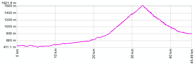
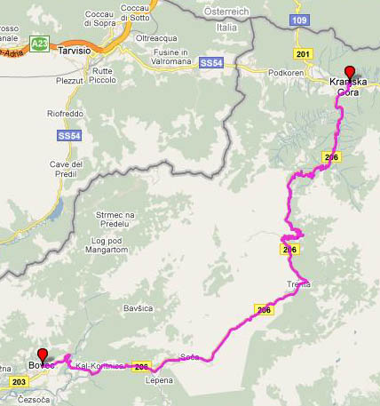
From South. I imagine one could
follow the river Soca upstream from the
medterranean sea. It follows the proximity of the
Slovenian - Italian border, its mouth in Italy,
then following the valley closest to the border on
the Slovenian side. Proceeding upstream, at
Kobarid the river has reached an altitude of about
340 meters. From here the road following the river
rolls along in the canyon, gradually gaining
altitude. At the sports friendly town of Bovec the
majority of traffic heads for pso di Predil, while
this route enters Triglavski Narodni National
Park. The road now stays close to the increasingly
narrow steepsided limestone canyon to the park
headquarters town of Trenta. There is only a
single tunnel (galery style) along the entire
approach. The tranquility and this little town is
remarkable, considering its location at the center
of such a spectacular setting. This is where the
real climb starts. The switchbacks are numbered
backwards and labeled with altitude, so we start
climbing at switchback 48. The first 8 come right
in a row, then long straight stretches climbing at
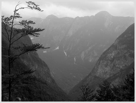
14% make clear that this is quite a workout. There
are basically two views, back down into the V
shaped canyon where Trenta sits, and ahead to the
upper source of the Soca with block shaped peaks
far above. Each climbed switchback gives a new
vantage point on these two views. At about 1000m
the road diverts to the right into a high hanging
canyon and the summit house becomes visible. But
the climb remains steep till the last meter to the
summit
From North. (described downwards). The
views on this side onto the peaks Spik (2472m) and
Skriatica (2740m) are even more precipitous than
the last part of the ascent on the other side.
During my crossing a southerly airflow blew open a
hole in the clouds, creating great afternoon light
conditions. On this side the switchbacks are
cobble stoned while the intervening straight
stretches are asphalt. This does a good job
slowing down the motorcycles. A WW1 burial ground
is also located near the top. When the switchback
countdown reaches number 3, the road is still at
over a 1000 meters altitude. This means a good
long roll out down to the town of Kranjska Gorka
and its large houses with even huger roofs. This
is a realtively upscale ski resort so a majority
of the many apartments and sobes have more than 2
stars.
A Day on a Tour: (<Pso di San
Osvaldo|Pso di Fusine, Pso Cason di
Lanza>) Vrsic Pass: Kobarid .> Bovec >Trenta
>Vrsic Pass > Granjska Gora: 50miles with
5400ft of clibming in 5:3hours. (VDO MC1.0
m3:9.6.15) Dayrides from the starting point of this Extended
Tour day, Kobarid, are on pages: A Dayride with this point as highest summit: COMPLETELY PAVED ( < Hirschbichlpass
| Cesta na Mangart
> ) Vrsic Pass, Passo de Predil:
Womostellplatz along Alpe-Adria pista cyclabile
near Fusine > Kranjska Gora > Vrsic Pass
> Soca > Predil Pass > outskirts of
Tarvisio > back to starting point near Fusine:
55.2miles with 6098ft of climbing in 5:28hrs
(garmin etrex30 r5:21.9)
back to
Cycling Passes in Europe |
||||||||||||||||||||||||||||||||||||||||||||
 Approaches
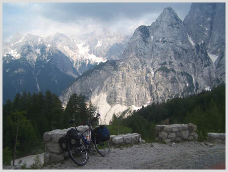
|
|
advertisement |
|
|
advertisement |