< Left Panel   Passes in Italian Alps   Areas   Tables   Maps   All Favorites  
Main Panel:   Main Page   Map+Profile   Alps Map  


Passo Maniva

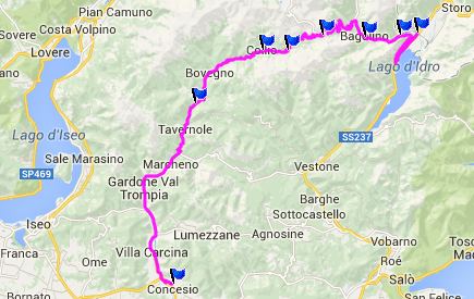
This pass connects Valle Trompia with Val di Caffaro and its Lago d'Idro. At the top of the pass a road crosses, leading to higher points in both directions. One of them is the Passo dell Spina, which is reportedly often impassable. In the other direction is Passo Crocedomini, which was still closed because of snow, during a time when practically all other passes above 2000m had been opened already. I don't think this pass has high priority in snow removal (if any at all), because it only serves tourist traffic.

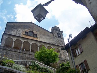
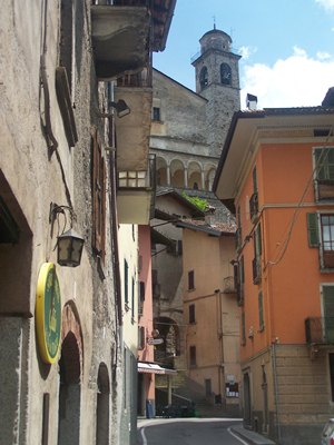
There is however one attraction common to all these crossings which is never closed, and for somebody not living here, it may be the most interesting view in the entire area, and that is the town of Bagolino, located where the routes to Maniva and Crocedomini divide. See pictures.


1.(390m,00.0km) START-END EAST: SS237 crosses Fiume Caffaro north east of Lago d'Idro
2.(690m,09.6km) intermediate high point
3.(740m,12.4km) Bagolino
4.(1664m,26.0km) TOP: Passo Maniva
5.(950m,35.3km) San Colombano
6.(840m,34.0km) Collio
7.(510m,48.6km) START-END WEST ALT: jct with road to Stravignino, Sant Apollonio and Colle San Zemo
8.(270m,71.7km) START-END WEST: Concesio

Approaches

From East.
Before starting this climb, one can rest up emotionally by rolling along the smooth straight bike path along the Valli Guidicarie. The road along Lago d'Idro begins to climb here and there is already the turnoff to Bagolino on a trusty roundabout. The road rises high above the lake and the area around the lake has a modern, spread out look. Only on the opposing hillside do the houses cluster together.

The road turns away from the lake and reaches a flat point, even rolls down a few meters. For the occasion a crucifix appears next to the road and the first really impressive mountain view appears. There are two paved routes to mountain passes from here. They separate in Bagolino, and after seeing Bagolino and looking around, there is a danger that there may not be enough time left for either one.
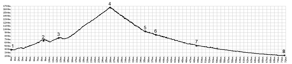
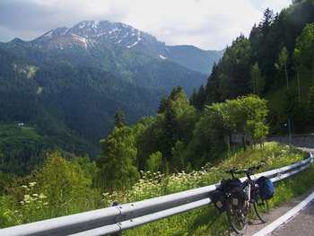
.
The reason is a cathedral that takes a stretegic lookout position above the town. I just had to walk up there. A good bench with a scenic view for lunch is also available below. Then comes the decision about which pass to climb, Crocedomini or Maniva. In my case it was very easy. Crocedomini was still closed because of snow, so Maniva it is.

The road to Passo Maniva starts with a series of switchbacks to climb the slope across from Bagolino. It's steep enough and consequently slow enough on a bicycle, that you still notice it, when the tree branches form a perfect frame around Bagolino from yet another new vantange point. Still - the switchbacks seem to take forever, and it is not until just before the last one that the road completely climbs above tree line. The snowy ridge in direction Passo Crocedomini is partially obscured from sight by lower hills.

The top is a ski area, so the pass itself is gigantic parking lot with an albergo at one end


From East.
(described downwards). There are actually 3 roads on this side. Two climb higher, Crocedomini, and also Passo dell'Spina, approaching from Anfo. But after having dragged all my heavy touring bags up here, I was very much in a mood to roll down. The stature of the peaks quickly rises as the road descends past quiet villages with a couple of interesting church towers


A Day on a tour:

PARTIALLY PAVED / UNPAVED:

(< Passo Lagostrello | Colle di San Zeno >)
Passo della Maniva , Passo dell' Ampolo
: Torbole > Riva de Garda > up Ponente > Molina di Ledro > Passo dell'Ampolo > Storo > Lodrone > Bagolino > Passo del Maniva > San Colombano : 50.6miles with 7289ft of climbing in 6:08hrs (Garmin etre30 m4:14.6.5)


--------------------------------------------------
Colle de Tamie

----------------------------------------------------

Colle de Tamie

----------------------------------------------


advertisement

advertisement