| |
| |
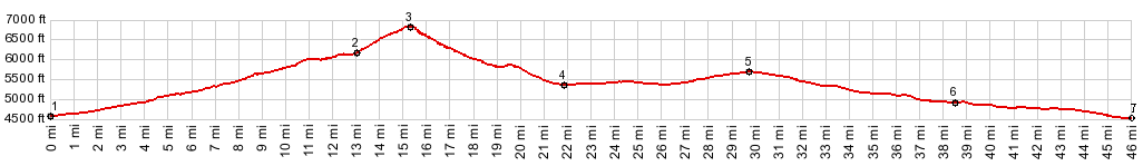
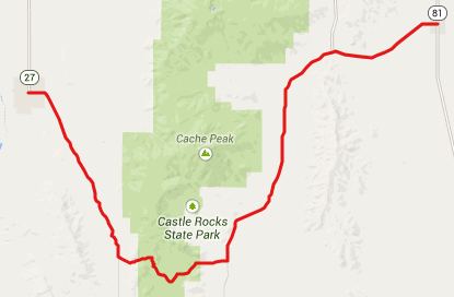
Elba Pass
Most people see the Albion
Mountains probably from I84, the interstate
racetrack across the Snake River Plain. From that
vantage point they look like nothing more than
oversized bread loaves. Elba Pass is a low gap in
the this ridge. It conveniently fits into a loop
through the picturesquely self descriptive "City
of Rocks" Preserve and over Emery Pass.
From West. Id77 starts climbing gently as
soon as it gets away from I64 and Malta.
Approaching Elba, a turnoff on the left leads to
Grandview Cemetary (or similar name) and right to
Elba Park, Independence Lakes and "national forest
access". That's the route the profile takes. To
get to the national forest the road stays right at
two t junctions, and stays left at one junction
(the other option dead ends at a house) Recently deposited, intermittent gravel makes
this road a little difficult on a bicycle. As you
cross into the national forest, a sign informs
that you are now on FR48. Later a sign reads
FR548. I think the 5 on the first sign is a victim
of a gun shot wound. Approaching the top of the
summit, I marveled at the views of several
hogbacks to the east, through which this road
passes on the other side. The ridges appear like
large frozen waves. At the top the open brush forest disappears and
gives way to a grassy ridge. According to the
signs you can continue along the ridgeline and
connect to Independence Lakes to the south and
Twin Lakes campground to the north via yet another
Skyline Trail. 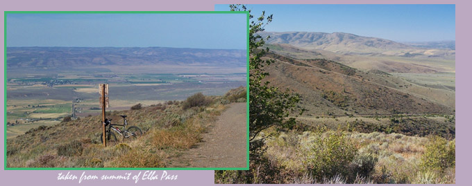 From East. No mystery where the road goes
on this side. Every inch is clearly visible from
the top, nestled between green grassy ridges, the
Snake River Plain and its crop circles dissolving
into distant haze. It's a smooth fast descent on a
nice, narrow road. Approaching the outskirts of
Oakley the road becomes heavily graveled, but only
for a short distance before it turns to a hard
surface. Dayride with this point as highest summit: ( < Brownlee
Summit | FR47
Blacksmith Fork Canyon Left Hand > )
|
 Approaches
|
|
advertisement |
|
|
advertisement |