B
|
Barlow
Pass -UNP- 4155ft- the first
historic road over the Cascade Range in
Oregon. Today you can get to the highest
point also with two paved approaches. But
one of the old historic approaches is now
a dirt road. |
|
|
Bennett
Pass -PVD- 4670ft- major
highway on the east side of Mount Hood
with one or two nice views |
|
|
BLM
23-8-28 Elliot State Forest(sh)
-PVD- 2260ft- paved Oregon forest
isolation, courtesy of Elliot State Forest |
|
|
Blue
Box Pass -PVD -4024ft-
nondescript highway through the Cascade
forest |
|
Buck
Creek Rd/ Lindy Bridge Rd s(u)
-PVD- 1470ft- this is a small summit in the
Oregon forest. But I had no idea there
were narrow isolated roads like this one
in the USA |
|
Buck
Creek Rd via Soup Creek Rd(sh)
-PVD- 1410ft- this is a variation on the
one above. But it reaches a different
summit point, therefore a separate page |
| C
|
Camp
Creek Road - BLM 25-7-5.1(sh)
-PVD- 2120ft- this is the highest point on
an interesting Oregon forest loop ride |
F
|
Fairview
Mountain Road s(u) -UNP
2240ft- dirt road climb above the Pacific
coast near Florence, but you don't see
much of the coast. Trees compensate. |
|
|
FR16
Vista Ridge s(u) -PVD- 3750ft-
the traffic free, highest point of a 96
percent paved ride around Mount Hood |
|
|
FR58
Klickitat Rd s(u) -UNP- 2160ft-
another Coastal Range dirt road, where
bicycles somehow seem smaller because of
big trees |
|
|
FR1828
Lolo Pass s(u) -PVD- 3690ft-
isolated, short, completely paved loop on
the west side of Mount Hood |
| L
|
Lolo Pass
-UNP- 3460ft- logging road on the west side
of Mount Hood, nice views of the mountain
with logging devastation in the foreground |
|
|
Luchsinger
Creek Rd s(u) -UNP- 910ft-
small dirt road climb next to the Umpqua
River, main attraction is deep forest
isolation |
O
|
Or35
Government Camp (sh) -PVD-
4030ft- wide, busy highway to Mount Hood
ski area. But this road is part of many
interesting loop possibilities |
| S
|
Salt
Creek Summit -PVD- 6070ft- a
series of long forest climbs in the Hell's
Canyon area |
|
|
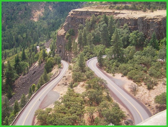
Seven
Mile Hill Rd s(u) -PVD- 1800ft-
this is one of the higher climbs next to
the Columbia Gorge |
|
|
SFR2000
Scholfield Ridge Rd s(u) -UNP-
1850ft- one of the higher climbs in
Coastal Range near Reedsport |
|
|
Steens
Mountains s(u) -UNP- 9550ft- massive
climb on a lonesome dessert mountain in extreme
eastern Oregon |
| T
|
Timberline
Lodge: Mount Hood -PVD- 5900ft-
this ride to a high point on Mount Hood,
is the biggest completely paved climb in
Oregon, that I am aware of. |
| U
|
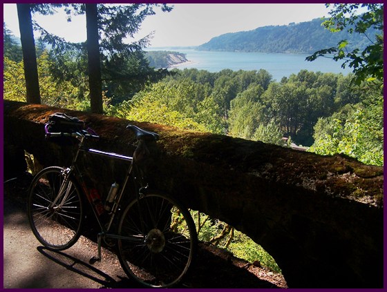
US30
historical: Canticlear Point(sh)
-PVD- 900ft- another very small, but
inversely proportional scenic climb, next
to the Columbia Gorge |
|
US30
Rowena Crest s(u) -PVD- 740ft-
this is really just a bump in the road.
But a little climbing goes a long way in
the scenery department next to the
Columbia Gorg |
|
|
US101
Cape Foulweather s(u) -PVD-
560ft- a tiny climb on the Pacific Coast
bike route. But if the weather is not
foul, the view is great. |