| |
| |
US30 Rowena Crest s(u)
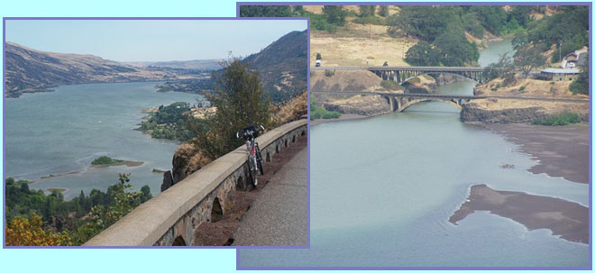
The historic Columbia
Highway, or better - what's left of it, runs
between Hood River and Rowena. The southern
part between Hood River and Mosiers is a
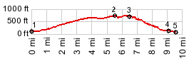
popular multi use trail. It reaches about
400ft above the river. This page is about the
northern part between Mosiers and Rowena. It
reaches a little higher, just high enough to
give me an excuse to make an elevation
profile. This is a small summit, but also a
very scenic area, so a little climbing brings
a lot in the visual department.
From West. From Mosiers
the road climbs gently with a view of the gorge
most of the time. Perceptually there are two
summit points. The profile shows that the first
one is a little higher. There is an interesting
viewpoint before you reach the first summit
point, looking out on an island with a simple,
yet clearly visible monument on it. I don't
imagine it gets to many visitors. An
informational sign informs that it was used by
native Americans to bury the dead, and that it
was already mentioned in Lewis and Clarke's
journals. From East. (described
downwards). The most comprehensive view point
along the way comes shortly after what feels
like the second summit. From Rowena Crest you
catch the first glimpse of the Columbia
downstream, as it continues its large meanders
into much drier country. "Glimpse" is the
understatement of the year. The view stretches
from the Dalles 90 degrees to the north, to the
two bridges over the Klickitat River, which from
up here look like the perfect N scale railroad
display. The view continues on the other side of
the road to a farm house that sits on staircase
of lava steps, like it was on a display case.
Once in a while a UP train runs the length of
this vista, traversing several tunnels,
separated by long stretches of racing the waves
of the Columbia, breathing life into this
magical miniature display. The way down uses a number of
ramps and switchbacks. It gives the whole ride
the feel of a small mountain pass, even though
the real climb is really extremely small. The
road continues along the river to the Dalles,
but the profile turns left and goes to Mayer
State Park, which is the perfect picnic spot and
lends itself to more river gazing, this time
from close-up. Dayride COMPLETELY PAVED: ( < Seven Mile
Hill Road s(u) | US30
historical: Chanticlear Point > )
-
|
 Approaches
|
|
advertisement |
|
|
advertisement |