| |
US30 historical:
Chanticlear Point(sh)
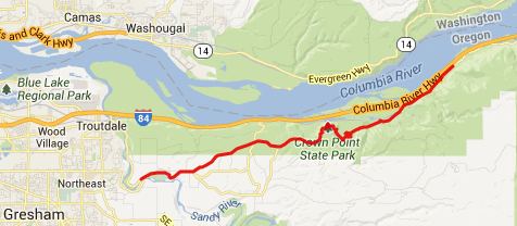
Following historical US30
east means following a road that was designed
with aesthetics in mind, very different from
today's modern roads. You immediately notice
the rock railings, that would never fit into
the picture of a road with a recent budget.
That and many other things make this road a
joy to ride on a bicycle. This little summit
has two great view points. Here, what man
built, really harmonizes with what nature
built.
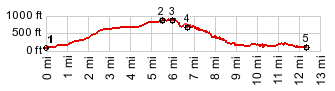
From West. The profile
follows historical US30 (this is a different
road than US30 in most places) from Troutdale
east. This is a really mellow climb through
woods, with one Mount Hood sighting from near
the Corbett High School. Near the summit , but
before the first viewpoint, is a junction with
an an optional much steeper approach to this
route via Corbett Road. But to get to lower
start of Corbett Road, you have ride on I84 to
exit 22, legal but noisy. Following along the almost
suburban top of the plateau, the route on the
profile passes what was for me the nicest view
point of the western Columbian Gorge:
Chanticlear Point. The view stretches west
to the other obligatory stop on this route, a
pavilion like structure, perched on a rock above
the Columbia: Vista House. Below it, vertical
rocks lead to a blue surface with choppy white
waves. Beacon Rock, a free standing rocky
mountain on the other side of the Columbina,
makes the exlamation mark in the landscape.
Another reason this place makes such a harmonic
appearance is the way the view point and its
surrounding construction, consisting of
monuments, stone railings and landscaping is
structured. It seems to be a place where nobody
cannot smile when they have their picture taken. Past the viewpoint, the road
reaches its highest point near the turnoff up
Larch Mountain Road. From East. The second view
point is quickly reached. It is on the opposite
side of the road where you would expect to be.
The inside contains a number of interesting
history tidbits about the historic Columbia
Highway. The road quickly enters dense forest. A
number of old bridges with interesting stone
work and waterfalls give more reasons (not
excuses) to stop. One that I enjoyed
particularly, and pictures are included here is
the maybe 100ft long trail into Sheppard's Dell. The profile continues to Bridal
Veil State Park, also a junction with US30 and
I84. Dayride with this point as
highest summit: ( < US30
Rowena Crest(sh) | FR99 Bear
Meadow s(u) > ) - |
 Approaches
|
|
advertisement |
|
|
advertisement |