| |
| |
FR99 Bear Meadow s(u)
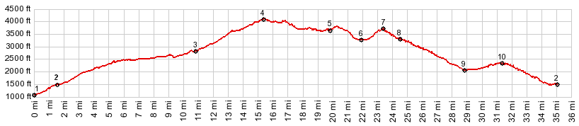
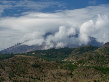
Approaching the Bear Meadow viewpoint on FR99 for the first time, I suspected that this was the first of many great views onto Mount Saint Helens - and I was right. I also suspected that this was only a waypoint to two higher passes on its slopes, Independence Pass and Norwegian Pass. Mostly I was wrong about that. Yes, Independence Pass is a few feet higher. But it is located on the out and back road to the Windy Ridge viewpoint, and the road keeps climbing gently after the pass, and so the road does not really "cross" the pass. Norwegian Pass also may be some sort of water divide, but as seen from the road, it's just a point along the downhill of the northern approach to this point.
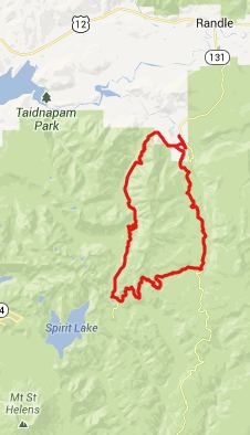
From East. Turning west
from FR25 Elk
Pass (see that page for a description up
to here), a fairly steep forested climb leads to
a sublime view point point onto Mount Saint
Helens, behind a nicely crafted stone wall. For
me, every time I reach this point, is a moment
of suspense. What cloud cover will the mountain
be wearing this time, fully cloaked from head to
toe, a slowly lifting veil, or a lentil shaped
cap perhaps ? From West. But actually
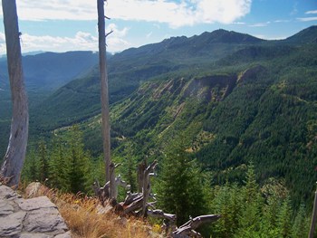
this side is the one, that is really
interesting. The road enters the National
Monument, with a panoramic view of the stick
forest left by the 1981 explosion of Mount Saint
Helens. The road quickly arrives at a bottom
with a short trail to Meta Lake and the choice
of two passes to climb from here, Independence
Pass to the south or Norwegian Pass to the
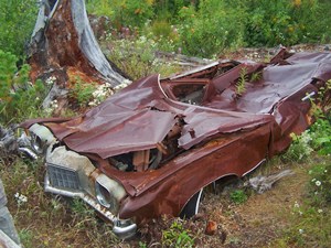
right. At the junction is also a view
point with the curious name "Miner's Car". The
Park Service has erected a small wooden
enclosure around the remnants of a 1973 Pontiac.
And why not ? Car wrecks have been a favorite
photography subject for me too. This particular
one belonged to a family of miners, who hiked to
their cabin from here just before the 1981
eruption. They never came back, and the car is
now an official volcanic National Monument view
point. It reads: "From tragedy comes knowledge".
I'm not sure if this is an attempt at dry humor.
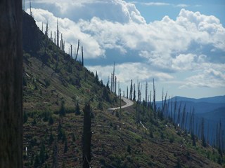
In any case it's poignant enough. The profiled route turns right
here and follows a narrow rarely driven road,
down over what is labeled as "Norwegian Pass" on
maps along the road. Between here and the
junction with FR25 I saw only one car, and the
driver asked me if this road was "going through"
now. Well - as it turns out, it was going
through. But there are so many sloughs and
sunken pavement sections on this stretch, that
few cars dare tackle it. Vegetation has started
to claim the road edges, so that this stretch
has the pleasant feel of an abandoned road. The
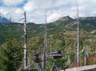
first part continues through the wild match
stick forest, that was left after the eruption,
followed by a very steep climb above this
matchstick world. After the next decent the road
enters deep forest. Only when approaching the
jct with FR25 does a clear cut appear - with
Mount Adams in the background. The
profile ends on a point of the other approach.
Dayrides with this point as
highest summit: COMPLETELY PAVED: ( < US30
Historical: Chanticlear Point | Red Rocks
Pass > ) ( < Red Rocks
Pass | TR216D
Abraham's Trail s(u) > ) A Dayride with this point
as intermediate summit is on page : TR207
Abraham's Trail s(u) |
 Approaches
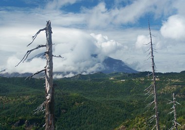
|
|
advertisement |
|
|
advertisement |