| |
| |
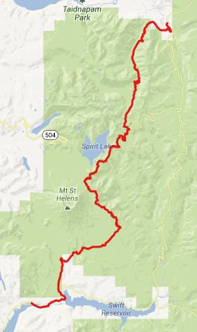
TR216D Abraham's Trail
s(u)
The ride to the Windy Ridge
veiwpoint on Mount Saint Helens makes a great
paved out and back ride. But in order to make
this into a loop, you need a mountain bike,
and then the possibilities are virtually
endless. Two single track trails and a dirt
road connect to the upper part of Windy Ridge.
The highest one of these, is also the one
closest to Mount Saint Helens. TR216 Abraham's
Trail reaches a few hundred feet above the
highest point on the Windy Ridge Road, which
is located at Smith Creek viewpoint.
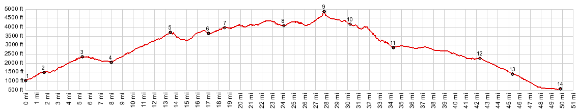
The profile tries to show two large opposite approaches, using paved roads for the lower sections. A day loop over the summit will most likely loop back to the starting point and not connect the endpoints.
From South. The profile
starts a little below, where FR26 leaves FR25,
about 10 miles south of Randle. That portion is
described on the FR99 Bear
Meadow s(u) page. After traversing the
point, labeled Norwegian Pass on some maps (not
really a pass with two uphill approaches), this
route turns right to continue on pavement to the
Windy Ridge view point. On these final miles the
road enters deeper into the blast zone of the
the 1980 eruption. Whatever trees are left, are
lying on the ground in a pattern that shows the
direction of the blast wave. A few others are
lonely remaining sentinels to a past forest.
This starkness of the scenery gives the
impression, that the road is climbing great
heights, but it is really only the ecozone that
is changing, and the road rolls along, loosing
almost as much elevations as it is gains.
Traversing meanders of the road serve as
foreground to a ridge, that only often sheds its
clouds as the day heats up. Several view points along the road
are dedicated to Spirit Lake, a lake that used
to be lined with holiday cottages, when the
level of the lake was still 200ft lower, before
the eruption. Surprisingly now its shores are
still densely filled with floating lumber. The
paved road reaches its highest point at the
Smith Creek overlook, where the view reaches in
both directions, Spirit Lake to the north and
Lava Canyon to the south. Another single track
trail reaches the road here, and it can be used
together with Abraham's Trail to make a (nearly)
complete single track loop. At the end of the road, just past
the Windy Ridge viewpoint, a narrow, closed dirt
road continues towards the slopes of Mount Saint
Helens. At its beginning a map shows all the
trails and waypoints along this route. The road,
desginated TR207 traverses along a treeless
ridge towards the volcano. The road ends
quickly, and just 1/4 mile before it does, a
steep single track trail, TR216D climbs a small,
narrow ridge, and stays at the exact knife edge
top over all its ups and downs. With each pedal
stroke the view of Mount Saint Helens improves,
often not only because of the higher vantage
point, but also because the warmth of the day is
lifting more and more clouds from it. But taking
one's eyes off the trail may be a little risky. Slowy the ridge ride becomes a
traverse, still heading straight in an imaginary
line for the top of Mount Saint Helens. As this
becomes impossible, a series of rope steps serve
as walking aid where the bike has to be pushed
to the top of a ridge again. The summit is
reached during the traverse that follows. From North. (described
downwards). This traverse soon ends ends on the
plain of Abraham, a vast inclined plain of
volcanic debris that stretches down from almost
the crater. The junction with TR216, and another
trail heading towards the volcano really feels
like the summit, but it is actually lower than
the preceding traverse. The trail quickly exits the plain
of Abraham, passing by a deep slot in the rocks
below, where the trail is fully exposed. The
remainder of the route,now TR234 Ape Canyon,
follows a wooded ridge above the volcanic debris
on a very smooth trail through dense forest.
When the trail ends, it is on the "plain of
Abraham" again. How can this be ? It
demonstrates just how inclined this plain is.
This point feels like a different world than
riding "the plane of Abraham" did the first
first time. But it really is only 1500ft lower
than the spot that felt like the summit. That is
less elevation difference, than the paved road
from here looses to its low point a few miles
west of Cougar. Dayride. PARTIALLY PAVED / SINGLE TRACK ( < FR99 Bear
Meadow s(u) | Chinook Pass
> ) - |
 Approaches
|
|
advertisement |
|
|
advertisement |